
 The 500 mb cutoff low is currently centered along the California-Baja border (top image). The morning NAM forecast indicates that the associated vorticity maximum will have swung across southern Arizona by tomorrow evening. Precipitable water amounts over southern Arizona are currently less than an inch, and dry air at 700 mb and above lurks only a couple of hundred km south of the border (as per morning Guaymas sounding). So the impacts of this event over southeast Arizona will likely depend upon: how much moisture attends the core of the cutoff; how much warm, dry air at 700 mb may be pulled in ahead of the low; and how much instability will be present late tonight and tomorrow. Very tough forecast situation. Nice summation provided in the Tucson NWS 2:50 am FD:
-------------------------------------
DISCUSSION...UPPER LOWS ARE A WEATHERMANS WOE WHICH ALSO HOLDS TRUE
FOR THE COMPUTER MODELS. WATER VAPOR IMAGERY THIS MORNING SHOWED THE UPPER LOW OVER NORTHERN BAJA...OR JUST SOUTH OF IMPERIAL CALIFORNIA. ALL COMPUTER MODELS THAT I HAVE LOOKED AT THIS MORNING WOBBLE THE UPPER LOW NEAR THE CALIFORNIA/MEXICO BORDER INTO THIS AFTERNOON BEFORE UPSTREAM PACIFIC SYSTEM APPROACHING 130W GIVES IT THE BOOT INTO SOUTHWEST ARIZONA TONIGHT AND ACROSS SOUTHEAST ARIZONA ON
THURSDAY.
--------------------------------------
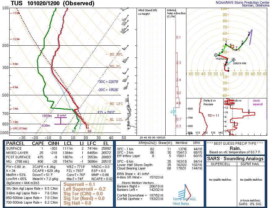
The morning Tucson sounding (middle image) indicates some small amount of CAPE present and this should increase - as long as the warm, dry air at 700 mb doesn't intrude northward across southeastern Arizona. The morning NAM forecasts that a north-south band of rainfall (bottom graphic for QPF during the 36-hour period) of up to a 1/4" will be centered out west of Tucson by the time the event has mostly ended at 5 pm tomorrow. So the NAM model apparently doesn't generate much CAPE from here east, although the model forecasts a significant rainfall event east of the Continental Divide in New Mexico.
--------------------------------------
So, even though the event is knocking on the door, it's detailed evolution remains somewhat unclear.
--------------------------------------
Jim Means reports regarding this event in the San diego area:
Hi Bob, I wanted to pass along that the cutoff low has been a MAJOR event for Southern California. Rainfall around San Diego county has ranged from about 1 to 3 inches. I've seen unconfirmed Alert gauges with readings up to 7 inches. We got a little lightning early yesterday morning but that was about it. I'm hoping for a little more today before the fun moves into your area.
No comments:
Post a Comment