Saturday, August 06, 2016
Some Storms At Lower Elevations Yesterday
There were afternoon thunderstorms, and some showers also, at lower elevations yesterday - as per the ALERT network plot for 24-hours ending at 7:00 am MST this morning. Certainly a hit and miss pattern over the entire network. Only 23 of 93 sites had rainfall and two spots that measured more than a quarter of an inch were just east of Picture Rocks and on the north side of the Catalinas. Here at house we had a brief, heavy shower during mid-afternoon that produced 0.10" but no thunder. Later in the evening we had thunder from a cell to the south, but no more measurable rainfall.
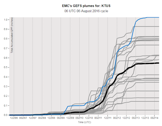
The morning sounding for TWC (above from SPC) shows that our local atmosphere continues to dry and stabilize. The models forecast PW to fall to around an inch by late afternoon, with only very isolated storms over most of southeastern Arizona today, and it looks like we'll have a few days of down weather. However, a developing disturbance near the southwest coast of Mexico is expected, by NHC, to strengthen and merge with the remnants of Hurricane Earl. This new storm is expected to track toward the south end of Baja and push higher moisture back north. This is reflected by the 06 UTC QPF plumes from the GEFS below, which forecast a dramatic increase in chances for rainfall at midweek on 10th and 11th.
Meaning, enjoy the down period after the very wet past 11 days.
Subscribe to:
Post Comments (Atom)


No comments:
Post a Comment