Friday, October 17, 2014
Bands Of Very Light Showers Over Arizona
A weak, middle and upper-level short wave is moving into Arizona today from the Pacific. There are several bands of very light showers ahead of this feature. The graphic above is TUS NWS radar composite chart for 8:22 am MST this morning - showers are moving generally northward while the bands are inching eastward. Visible satellite image from 8 am below shows that most of Arizona has heavy cloud cover this morning.
Perspective from the water vapor image, at same time above, indicates the upper-tropospheric vorticity center is probably near Yuma this morning. The 12 UTC TUS sounding plot below indicates that cloud bases are very high - near 500 mb (i.e., around 16,000 ft msl) with temperatures at cloud base being around -6 to -10 C. Today's short wave will be followed by another on Sunday and yet another Wednesday - so some cloudy periods and perhaps more light showers off and on for next five days or so.
Tuesday, October 14, 2014
Gonzalo Becomes Cat 3 Hurricane In Atlantic
The NHC has upgraded Gonzalo first to a hurricane today and now to a Category 3 storm. Visible image above is from 2115 UTC this afternoon and shows Gonzalo well to the north of Puerto Rico. The wind speed probabilities plot below shows that the current track forecasts take Gonzalo near Bermuda, which is cleaning up after being struck by Fay.
Monday, October 13, 2014
Royals VS Orioles
Looks ugly for the baseball playoff game this evening in Kansas City. Above is current NAM forecast of 6-hour rainfall ending at the start time of the game.
Sunday, October 12, 2014
The Week Ahead
Tropical Storm Fay struck Bermuda overnight with some wind gusts over 80 mph. The storm is now expected to move rapidly east-northeastward. The NHC forecasts high chances of development of a depression or storm from a disturbance that is currently approaching the Windward Islands. Above is current NHC activity chart for the Atlantic and below is a visible satellite image from 1345 UTC this morning.
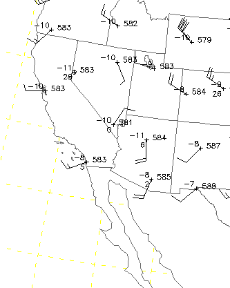
Over the U. S. the coming week will feature unsettled weather over the central and eastern portions of the country, as well as the far Northwest. A 500 trough currently over the northern Rockis will will amplify as it moves southeastward across the Four Corners Region, developing into a major trough over the Southern Plains. This system closes off and moves slowly eastward during midweek, before imapcting the northeast. Shown here are the GFS ensemble 500 mb means and spaghetti plots. Above graphic is valid at 1200 UTC on 15 October and below is valid at 1200 UTC on 19 October. The GFS ensemble members display little spread in their forecasts (except high latitudes, through next weekend. The West will enjoy mostly mild and fairly typical Fall weather.
Saturday, October 11, 2014
Isolated Mountain Storms Eastern Arizona
Residual low-level moisture will support some isolated mountain thunderstorms over eastern Arizona. Above is 12 UTC WRF-NAM forecast of radar echoes valid at 3 pm MST this afternoon. We were in Phoenix yesterday, and there were visually impressive thunderstorms, in the distant northeast to east, during the late afternoon and evening. The models forecast a repeat today as a weak, 500 mb, short wave moves across the state. Further drying is forecast after today, Below is the 06 UTC WRF-NAM forecast of PW valid at 10 pm next Monday night - significant PW is pushed far south to Sinaloa and lower latitudes, so several very nice days on tap here.
Thursday, October 09, 2014
Early Morning Showers Still Around Metro Area
The above view shows the Catalinas shrouded in heavy cloud yesterday afternoon around 5 pm. Rains were heaviest in the metro area yesterday around noon to 2:30 pm MST - DM received over an inch from those showers and there were some embedded thunderstorms. Driving around north-central Tucson was a real nightmare around 2 pm yesterday, as the streets were essentially running washes. At 5 pm we had received a total of 0.65" here at house, but then there were more showers around 9 to 10 pm and heavier showers after midnight, through the early morning hours. It is still raining lightly and all I know about current amount is that it is over an inch. (Through 7:30 am MST this morning event total here at house is 1.72 inches.)
The plot above shows that CG flashes were very limited for the 24-hours ending at 12 UTC. There were thunderstorms ongoing at sunrise up in the Rim Country and also a heavy storm was moving through the east side of the Phoenix metro area. This has turned out to be quite some rainfall event, particularly in the Catalinas, which have received the heaviest rains here in southeast Arizona during the past 24-hours. The plot below shows 24-hour rain amounts over the Catalinas sector of the ALERT network at about 5:30 am - note two stations reporting over 3 and 4 inches! Across the entire ALERT network there was 100% coverage and an amazing number of stations (45, or approximately 50% of the sites) reported over an inch of rainfall for last 24-hours. Five sites had amounts over two inches.
This event has unfolded as a weak, 500 mb trough in the westerlies has interacted with the low-level moisture plume from Simon that covered most of Arizona yesterday morning. The remnant low-level circulation of Simon got hung up around the Baja spur yesterday, while the middle-level pieces sheared off to the northeast. The NAM 500 mb analysis at 00 UTC last evening (above) indicates two vorticity maxima within the broad trough over the Southwest. The one over northeast Arizona may once have been directly associated with Simon. The stronger maximum near Yuma has been moving across Arizona during the night, with bands of showers ahead of it - thus, the two distinct periods of heavy rains over the metro area and local mountains. Shown below is 00 UTC NAM analysis for 250 mb, with upper-level trough still back over central California.
The various model forecasts from 00 and 06 UTC forecast the early morning showers here reasonably well - as opposed to the first go-around at mid-day yesterday. The main part of the short-wave will be moving on out of Arizona by evening, but the possibility of at least isolated showers will remain until this trough is well past us.
Wednesday, October 08, 2014
Thunderstorms And Showers Across Most Of Southeast Arizona
Thunderstorms developed yesterday afternoon as PW increased from the south and CAPE developed. The plot of 24-h CG flashes through 12 UTC this morning above shows that storms stayed mostly over higher elevations to the south of Tucson. More showers moved across southeastern Arizona after midnight, producing at least light rains at almost all observing sites. Across the ALERT network 86 of 92 stations measured rainfall - amounts were generally 1/10 to around a 1/4 of an inch. Three sites had over 1/2 an inch and Keystone Peak measured 1.14 inches. The Sasabe RAWS site had 1.27 inches. Amounts were generally heavier over the southwestern sector of the network - see below plot of 24-h amounts ending at 5:00 am MST this morning. here at the house there was 0.12" in the gauge.
In addition to increasing moisture and CAPE, a fairly distinct 500 mb circulation developed during the afternoon over western Arizona - 00 UTC 500 mb plot below from NCAR RAP. The 00 UTC 500 mb NAM analysis indicated that this circulation and vorticity max was separate from that to the south with Simon. This circulation brought in cooler midlevel air, helping to spark the early development of storms. The rainfall was not predicted by most of the models in the 00 UTC runs nor in the midnight runs - the HRRR model did pick up on the storms in southeast Arizona, but I don't know if this was a response to radar indications or an actual forecast prior to any activity. At this time it is not yet clear whether Simon's remnant circulation at low-levels has crossed Baja.
Tuesday, October 07, 2014
Meanwhile Out In The Western Pacific
Jack Diebolt sent the above 2201 UTC visible image of Super Typhoon Vongfong, which is far out in the western Pacific. The IR image below is from 2132 UTC and shows that Vongfong is about directly south of southern Japan. At bottom is current forecast for the super typhoon from the Joint Typhoon Warning Center. Current wind speed estimates for the storm are sustained winds of 155 kt (178 mph) with gusts to 190 kt (219 mph).
Weather Situation Changing Slowly
This morning Simon is still being called a tropical storm, although the deeper cloudiness has mainly left the low-level circulation behind. The visible image above from 1430 UTC shows Simon located almost due west of the Baja Spur, with thick cloudiness extending from Baja and northwestern Sonora into southern California, Arizona, and the Great Basin. An IR image from the same time shows that currently deep and very cold cloud tops are very limited in extent and over Baja. The NHC currently forecasts the remnants of Simon to decay near the Arizona border southeast of Yuma.
The main role of Simon in the developing weather event over the Southwest will be the low-level moisture that feeds well north of Simon's remnants. The WRF model forecasts from early this morning remain very similar to those from yesterday. The forecast above is from the early WRF-NAM and is for 850 mb winds and dewpoint temperature - valid time is 6:00 am MST on Thursday morning the 9th. Very high dewpoint temperatures, for this time of year, extend northward all the way to southern Nevada as the weak, 500 mb trough from the Pacific consolidates over the lower Colorado River Basin. Significant CAPE and thunderstorm activity activity develops ahead of the trough, initially far to the west of the Tucson area. Also of interest, is that the forecast above indicates that Simon's remnant circulation is stuck on the mountains north of the Baja Spur and that a new low develops ahead of the trough, north of Yuma.
The 500 mb trough is forecast to move across Arizona very slowly and significant CAPE doesn't develop over eastern Pima County until Thursday in the WRF forecasts. The slow movement of the trough in the westerlies will mean that the potential is significant for locally heavy rains, particularly where southerly, moist winds interact with the terrain and/or where training echoes develop. The forecast below is from the early WRF-NAM and is of total rainfall amounts through 11 pm MST on Thursday night. The WRF-GFS version seems way too wet, to me, as it was in the Odile situation - the GFS version forecasts rain amounts of over 10 inches out at the far western edge of Pima County. Regardless, it appears that the overall event will continue to evolve slowly through the rest of the week.
Monday, October 06, 2014
Simon Seems Not So Simple
Tropical storm Simon is now located southwest of the Baja spur with max winds estimated at 40 kt. Simon is weakening rapidly and becoming a remnant low, as it's middle-level circulation detaches and moves northward away from the low-level circulation. The visible image above, from 1430 UTC, shows that deep convection is no longer directly with the surface low, but is displaced from north through east of Simon. High-level cirrus from Simon now covers most of southern Arizona and some of southern California.
Low-level moisture from Simon has been feeding thunderstorms over western Mexico and Baja - plot of CG flashes detected through 0700 UTC is shown below. No thunderstorms yet this side of border, as PW remains very low - dewpoints have moved into the 60s out around Yuma, but morning sounding indicates moist layer is very shallow currently.
The sounding from Empalme this morning (second below) indicates 46 mm of PW and substantial CAPE and also CIN, so storms most likely on the mountains in Sonora. There is no organized wind field below 400 mb at Empalme this morning, so no strong advective fields are acting on the mT air as of this time over the GoC.
It appears that the middle-level vorticity associated with Simon will be picked up by the developing 500 mb trough west of southern California and move northward across western and northern Arizona, as the winds around the trough increase in speed. The NHC currently predicts the remnant depression from Simon to move into southern Arizona in a couple of days - track is quite similar to that forecasted for Odile last month. The WPC (once called the the Heavy Precipitation Center) predicts rainfall amounts through Wednesday as per graphic above - the WPC forecast indicates the heavy rains moving along the NHC predicted track for the remnants of Simon.
The rainfall forecasts from the early run of the WRF model at Atmo are quite different from the WPC forecast - graphics above and below show WRF rainfall predicted through 11 pm Wednesday night. Neither model forecasts much rainfall until cooler air arrives at middle-levels with the the California trough and thunderstorm activity develops. The GFS version (above) forecasts one swath of heavy rain stretching up the Colorado River Basin and extending into the western Rim Country, with a second swath across the northern GoC and into parts of Pima and Santa Cruz Counties.
The NAM version of the model (below) keeps the heaviest rainfall out in western Arizona. Both versions of the WRF forecast a weak surface low to move northward across western Arizona during the day on Wednesday. I took a careful look at the model forecasts on the 5.4 km grid and the low in Arizona seems to develop as the 500 mb trough approaches, with the Simon remnant low remaining to south and west (through 11 pm Wednesday). So right now it appears that anyone who wants more rain from this situation can find a model forecast that will make them happy - but which of the forecasts will be closest to what occurs in the real world?
Sunday, October 05, 2014
SSTs September VS October
Art Douglas sent above analysis of SST on August 30 showing the very warm SSTs over eastern Pacific, and Jim Means sent the same analysis but for October 1st below. There has been some cooling south of the mouth of the GoC, but main cooling has been west of 116 W. Several hurricanes have been mixing thing up in that area, probably causing some of the cooling. Simon is now over this cooler water and weakening rapidly.
Simon Is Wildcard Game For Mid-Week
Hurricane Simon (IR image above is from 1330 UTC) has been weakening rapidly this morning, as it moves northward over cooler SSTs. However, mT air with high PWs has been inching northward up the GoC, even though surface winds are light and variable over most of GoC. Image below is blended PW from CIRA at Colorado State valid at 1300 UTC (greens are over an inch and reds are over two inches). So, there is a very strong moisture gradient over the northern GoC and northwestern Sonora.
Second image below is current NHC forecast for track of Simon. The NHC forecasts Simon to eventually approach Baja as a remnant depression and then head into northwestern Sonora - somewhat similar to what it forecast for Odile last month.
The models continue to have a wide spread in their forecasts of where Simon's remnants will eventually track. To give a feel for this I show the NAM (above) and GFS (below) forecasts of 850 mb winds and heights, and also of PW. The forecasts are from 0000 UTC last evening and are both valid at 1200 UTC on Wednesday, October 8th. The NAM forecasts elongate Simon into a weak, inverted trough that extends just into southwestern Arizona. However, the GFS is more aggressive again and forecasts Simon's remnant circulation at 850 to move northeastward into Arizona, just south of Tucson. The NAM is somewhat similar to the ECMWF.
All models do forecast much increased PW into southern Arizona, as a weak, 500 mb trough approaches from the west. So, weather situation will be very complicated Tuesday through Thursday, with much depending upon how much moisture and instability develops over southern Arizona to interact with the trough. Not at all possible to forecast the details until Simon's demise process becomes more clear with time.
Saturday, October 04, 2014
Update 11 am MST - Simon Now A Category 3 Hurricane
Hurricane Simon has been rapidly intensifying during recent hours, A NOAA aircraft flight into the storm within the hour indicated maximum sustained surface winds of about 115 mph. This makes the storm currently a Category 3 hurricane, and it is the eighth major hurricane of the eastern Pacific season. The visible image below is from 1730 UTC.
Hurricane Simon continues moving west-northwesward away from southern Baja this morning. IR image above is from 1330 UTC. Current NHC forecast of Simon's track (below) takes the storm out to about 118 W before re-curving it northward and then northeastward. Simon will remain somewhat a question mark, wrt to impacts - if any - on southern Arizona, until early next week. Current WRF forecasts from Atmo keep high PW associated with Simon along and south of the border through midnight Monday night.
Friday, October 03, 2014
What Will Become Of Simon?
This morning (Friday, October 3rd) TS Simon is is about due south of Cabo San Lucas (IR image above is from 1330 UTC) and moving west-northwestward. The morning forecast from NHC for Simon is shown below. Several things of note: 1) strong convection extends well northeastward from the TS, into the southern GoC at this time 2) NHC forecasts Simon to continue mostly westward until Sunday, when they forecast it to begin recurving under the influence of a trough in the westerlies approaching the Southwest 3) NHC forecasts Simon to become a hurricane during the day tomorrow, and 4) the track of Simon from NHC is fairly close to that forecast by the current run of the ECMWF - both the NHC and ECMWF seem to have been biased too far to the west for a number of this season's storms - so the actual track of Simon during the weekend will be important to watch.
At this time PW over the Southwest is VERY low, with values running around a quarter of an inch, or lower - above graphic is from CIRA at Colorado State and shows their blended PW analysis for 6 am MST this morning. The Southwest is very brown.
The current early run of the WRF-GFS model at Atmo forecasts a significant northward push of moist, mT air during the weekend. The forecast of PW below is valid at 11 pm next Sunday night. At that time the model forecasts high PW values to have reached the border in south-central Arizona. However, the model's forecast for the center of Simon at that time is north and east of the "official" NHC position forecast.
At this time, my guess is that the core of Simon will cross central Baja and move rapidly east-northeastward across northern Mexico headed toward the Plains. But, for southeastern Arizona the issue will be whether or not there will a strong enough intrusion of low-level moisture ahead and north of Simon to support showers and thunderstorms, ahead of the westerly trough mentioned above.
Thursday, October 02, 2014
Tropical Storm Simon
Tropical Storm Simon developed rapidly yesterday afternoon southwest of Cabo Corrientes - top image is IR at 12 UTC and just above is visible image at 14 UTC. Simon is the 18th named tropical storm of the eastern Pacific season. It has been a very active year, especially when compared to the Atlantic Basin, which has had very little activity.
The current NHC forecast (below) for Simon keeps it at tropical storm intensities and moves it along a path that is similar to that of Rachel. There is fairly wide spread within the global models concerning exactly where Simon might head after a couple of days, so the weather watch as the weekend approaches will be toward the south.
Wednesday, October 01, 2014
Comments On Odile Situation And Related Posts
Tony Haffer, MIC emeritus of the NWS Phoenix Forecast Office, wrote:
---------------------------------------
The two near misses reinforce the fact meteorology is an INEXACT science. I agree there is often an office “dynamic” (among other factors) that results in forecasters not updating forecasts going awry in favor of forecasts for improving conditions. That said, procedurally in the NWS there are operational priorities for all weather events. Updates for deteriorating weather and WARNINGS are the highest priority; whilst updates for improving weather, much lower. Consideration must be given to staff size, about a dozen meteorologists at each NWS office, as well as their 24-hr/day responsibilities, which include, Public and Aviation weather and Warnings; radar monitoring; telephone answering; social and electronic media communications. The dozen or so Mets maintain a 24/7 weather watch 365 days a year (as well as take medical and vacation Leave). This distills to two mets per shift, except during critical weather, when perhaps as many as four may be on shift together. Additionally, the staff’s responsibility covers an area something like 30,000+ sq. miles. Suffices to say the men and women who provide us weather forecast service MUST prioritize their actions to provide the most timely information that will result in actions to save lives and property. If observational data indicate a threat is CLEARLY over, then one can argue updating a forecast to say it’s not going to rain, is little more than paper/electronic exercise.
All this said, I strongly agree with you regarding the need for additional research relative to Eastern Pacific hurricane forecasting. While I feel you were overly polite calling NHC’s Odile forecasts erratic, I feel they were poor. NHC was constantly chasing the storm, and adjusting its track. Certainly the model guidance the NHC forecasters receive has room for improvement, but what I believe to be a glaring omission, is a serious lack of real time data. NHC forecasters have to do far too much estimating regarding Eastern Pacific storm strength and location (while NOAA/USAF hurricane hunter aircraft gather moss in the Southeast). Why is the Southwest ALWAYS shortchanged when it comes to dispatching equipment to probe Eastern Pacific storms? The answer, of course, is budgetary limitations. It is time for NOAA to reassess its de facto policy of not deploying hurricane hunter resources to the Eastern Pacific. More importantly, it’s time for NOAA to request, and for Congress to PROVIDE, funding so NOAA can provide a similar hurricane forecast SERVICE to the Southwest as it has always provided to the East and Southeast!
Tony Haffer, NWS (ret.)
---------------------------------------
The two near misses reinforce the fact meteorology is an INEXACT science. I agree there is often an office “dynamic” (among other factors) that results in forecasters not updating forecasts going awry in favor of forecasts for improving conditions. That said, procedurally in the NWS there are operational priorities for all weather events. Updates for deteriorating weather and WARNINGS are the highest priority; whilst updates for improving weather, much lower. Consideration must be given to staff size, about a dozen meteorologists at each NWS office, as well as their 24-hr/day responsibilities, which include, Public and Aviation weather and Warnings; radar monitoring; telephone answering; social and electronic media communications. The dozen or so Mets maintain a 24/7 weather watch 365 days a year (as well as take medical and vacation Leave). This distills to two mets per shift, except during critical weather, when perhaps as many as four may be on shift together. Additionally, the staff’s responsibility covers an area something like 30,000+ sq. miles. Suffices to say the men and women who provide us weather forecast service MUST prioritize their actions to provide the most timely information that will result in actions to save lives and property. If observational data indicate a threat is CLEARLY over, then one can argue updating a forecast to say it’s not going to rain, is little more than paper/electronic exercise.
All this said, I strongly agree with you regarding the need for additional research relative to Eastern Pacific hurricane forecasting. While I feel you were overly polite calling NHC’s Odile forecasts erratic, I feel they were poor. NHC was constantly chasing the storm, and adjusting its track. Certainly the model guidance the NHC forecasters receive has room for improvement, but what I believe to be a glaring omission, is a serious lack of real time data. NHC forecasters have to do far too much estimating regarding Eastern Pacific storm strength and location (while NOAA/USAF hurricane hunter aircraft gather moss in the Southeast). Why is the Southwest ALWAYS shortchanged when it comes to dispatching equipment to probe Eastern Pacific storms? The answer, of course, is budgetary limitations. It is time for NOAA to reassess its de facto policy of not deploying hurricane hunter resources to the Eastern Pacific. More importantly, it’s time for NOAA to request, and for Congress to PROVIDE, funding so NOAA can provide a similar hurricane forecast SERVICE to the Southwest as it has always provided to the East and Southeast!
Tony Haffer, NWS (ret.)
Subscribe to:
Posts (Atom)