

Yesterday was the first good storm day of the summer that we've been here for. Three pulses of storms moved across portions of southeast Arizona and the Tucson metro area. The first of these was around 4 to 5 pm (4 pm MST radar from TUS at top). The storm east of the airport produced gusts to 48 mph when it hit at the airport. The storms up north on the Catalinas intensified, producing heavy rains (more than 2.50 inches at one spot in a couple of hours), and then around 6 pm some damaging winds in the far northwest part of the metro area. Lightning and thunder from these storms occurred here at house but no rain.
---------------------------------------------------------
The next wave of storms affected the Catalinas and north part of town with a second area of heavy echo moving across the Green Valley region around 8 to 9 pm (middle radar is about 8 pm MST). These storms produced a spectacular lightning display here at the house with lots of booming thunder. But we got only some spits of rain, even though we could see that heavy rain was very close to the northeast.
----------------------------------------------------------
Another wave of storms moved in by 10:30 to 11:00 pm and these produced, finally, some moderate thunderstorm rains here at the house. Total in gauge this morning was 0.41". The NWS POPs for yesterday of 30 and 40% proved to be conservative, as most of the metro area (Zone 33) received measurable rainfall (88 of the 93 ALERT gauges), as did most of the reporting stations in southeast Arizona and also the BLM RAWS stations. In the ALERT network 29 sites had a half inch or more rainfall; 6 sites had an inch or more; and Green Mountain in the Catalinas had 2.72 inches.
----------------------------------------------------------
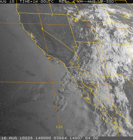
Northern Mexico was quite suppressed yesterday evening, after three days of strong MCS activity, with the storm zone shifted north into Arizona. A strong push of high Td air continues at Yuma, where early morning dewpoints were 75F with south winds of 20 to 25 mph. Apparently, none of the pulses of storms managed to push north into the Phoenix area. Finally, the bottom image shows heavy cloud cover covering the Southwest and Mexico this morning at sunrise, indicating a much more complicated forecast situation today than was the case yesterday.
No comments:
Post a Comment