Friday, February 08, 2013
Moisture-Starved System Approaches
A quick look at the approaching system. This morning's 12 UTC NAM analysis at 500 mb (above) indicates a cold and complex system - center of circulation is near San Francisco but a strong vorticity maximum is approaching Las Vegas. A stronger vorticity maximum is over the ocean west of San Francisco. Temperatures at 500 mb, near the core of the system, are below -30C, so definitely a cold event.
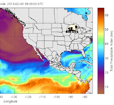
As per the last several systems, this one is also starved for a decent moisture feed. Both the Mimic (above from CIMSS for 09 UTC) and CIRA (below for 11 UTC) blended PW products show an inflow plume near San Diego, but with values only reaching to around 20 mm.
The early run of the WRF-GFS forecasts best band of precipitation (above is the forecast, composite radar image valid at 8 am Saturday morning) across eastern Pima County tomorrow morning. The surface plot forecast for the same time (below) indicates a raw morning with northwest winds, temperatures in the 30s and light rain showers. It will be quite a change! Total WRF-GFS forecast precipitation through midnight Saturday night is at the bottom, indicating light amounts, except in the mountains and higher elevations east and southeast of Tucson. Snow levels will come quite low along parts of I-10 and Highway 83, but ground and pavement will start out very warm. Some driving caution may be needed.
Subscribe to:
Post Comments (Atom)


No comments:
Post a Comment