Monday, December 14, 2015
Today And A Look Ahead
First - today's weather event, featuring a fast moving cold front with some showers. The forecast above of composite radar is from the 06 UTC run of the WRF-NAM at Atmo - valid time is 3:00 pm MST this Monday afternoon. The graphic below is from the same forecast run and shows precipitation amounts forecast through midnight tonight. The WRF forecasts (GFS version is very similar) continue to forecast light precipitation amounts over southeastern Arizona, with heaviest precipitation over the mountains, especially over northern portions of the state.
The forecast also indicates a period of gusty winds ahead of the cold front - above is WRF-NAM forecast of 10-m winds valid at 10:00 am this morning. Forecast of surface conditions below is valid at 11:00 am, just as front is coming into northwestern portions of the metro area. Temperatures are forecast in the middle 50's ahead of the front. But by 1:00 pm MST this afternoon (second below) the model forecasts significantly falling temperatures (upper 30's to low 40's F) with light rains across all of the metro area - will be a raw afternoon if model forecasts are accurate.
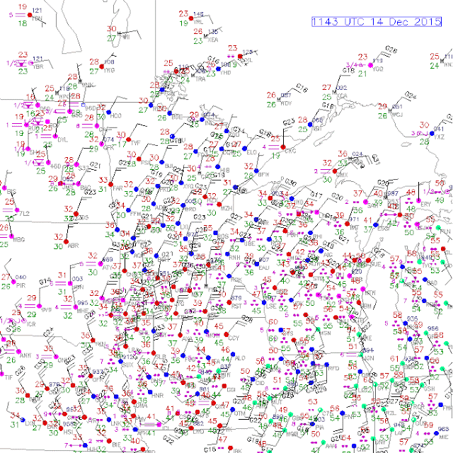
There is a significant storm (associated with Saturday's 500 mb short wave) impacting the upper-Midwest this morning. Given that it is mid-December, this seems to be a remarkably warm storm. The surface plot above, from a bit before 12 UTC, shows mostly rain, with temperatures near 50 F and moderate rainfall extending northward into Upper Michigan. There is a bit of snow along the back edge of the precipitation shield; but, my overall impression is that this is a fairly unusual event for December.
Looking ahead here, the global models are forecasting several storms for the Southwest during Christmas week. The ECMWF 500 mb forecast below is valid at 5:00 pm MST next Sunday the 20th. The ECMWF forecasts another, stronger, short wave into Arizona around Christmas Eve. Both of these seem to pick-up more moisture from the Pacific than have the recent events here. So, a challenging week for all who are planning to walk through the Christmas displays in Winterhaven.
Subscribe to:
Post Comments (Atom)


No comments:
Post a Comment