Tuesday, April 30, 2019

Yesterday And April Summary 2019

Summary for April is that there was not much to report. Rainfall here on 4 days - Trace on 3 days and 0.04" on the 16th. Only two days with low of 40 F or below, with coldest 38 F on the 11th. The 0.04" was a tie for second driest April in past 20 years.


Although there were showers and thunderstorms around yesterday, they mostly avoided the Tucson metro area.  Here at house there was very brief, light sprinkle and that Trace was it. The plot of CG flash density above is for 24-hours ending at 7:15 am MST this morning.

The composite radar, below from NWS PHX, shows that a number of strong storms were still around at 8:23 pm. 


Monday, April 29, 2019

Quick Update Monday April 29th


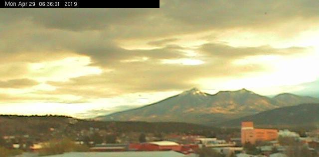
Chaotic skies this morning - above is west view from downtown Tucson at 6:30 am MST. Down at bottom is sunrise on the San Francisco Peaks from Flagstaff.


Upper-low moving eastward about as forecast by models - center now offshore west of San Diego. WV image above from 6:00 am.

Line of showers and some thunderstorms  far east of center and a bit east of Yuma - below is Yuma composite radar at 6:15 am. Yuma has reported several thunderstorms this morning, but only a Trace of rain. (Note that two strong echoes along I-8 in California and Mexico are from wind farms.)

Outlook continues for winds, dust, and some chance of light showers or sprinkles this afternoon.


Sunday, April 28, 2019

Unsettled Day Tomorrow


There is a mid and upper-level cyclone this morning out west of San Diego - above is upper-level water vapor image from 10:30 am MST and below is NAM 500 mb analysis at 12 UTC this morning. Models forecast this system to be kicked eastward and to move across Arizona as an open trough tomorrow afternoon and night (second below).


In addition to gusty southwinds tomorrow afternoon, the morning WRF models all forecast a line of light showers across Pima County during the afternoon (below is 12 UTC WRF-RR forcast valid at 4:00 pm MST tomorrow). So there is some possibility of virga and light showers or sprinkles here in metro area. Models also forecast a bit of CAPE ahead of this line - basically an unsettled day to bring the very dry month to an end.


Thursday, April 25, 2019

Thunderstorms On April 23rd


I was away unexpectedly yesterday, and I am not sure about rainfall on Tuesday. I think that there were a few showers and sprinkles around the metro.

Skies were quite ominous over parts of Tucson at mid afternoon on Tuesday - as per view above at 3:19 pm MST. The CG flash density plot below (from weather.graphics and Vaisala) is for 48-hours ending at 6:00 am this morning (the 24-hour plots indicates that storms occurred on Tuesday). Storm activity stayed mostly northeast and southwest of metro area, although there were a couple of flashes on the Catalinas.

Little to look forward to weather-wise except for a couple of hot, summer-like days.

Tuesday, April 23, 2019

Unsettled With Thunderstorms - Yesterday and Today


Thunderstorms developed across much of southeastern and southern Arizona yesterday afternoon - radar above from KEMX TUS radar at 5:39 pm MST. The flash density plot below (from weather.graphics and Vaisala) shows activity that developed west of Tucson and also in Pima County out around Ajo. Had a very brief shower here with large drops that just wet patio - however, only a Trace in gauge this morning.


View to north from campus at sunrise (above) captures a chaotic morning sky.


The 12 UTC 500 mb analysis (above from SPC) shows the closed low out to our wes, just about as forecast. A small, -20 C cold pool will be moving across the Borderlands today, bringing another chance of thunderstorms The morning sounding for TWC (below also from SPC) indicates a bit of CAPE  above 600 mb, but low PW and dry lower-levels - thus chance of some gusty outflows.


Forecasts shown here from 06 UTC WRF-GFS. Composite radar above at 5:00 pm today and total forecast precipitation through 5:00 am tomorrow below.  Again of note is fact that same run forecasts strong outflows of 40+ mph across much of Pima County this afternoon. The new 12 UTC forecasts appear to be trending toward a bit more thunderstorm activity for eastern Pima County than did the midnight runs.

Monday, April 22, 2019

Showers and Thunderstorms Tomorrow?


This morning's NAM forecast at 12 UTC indicates the 500 mb trough over Great Basin will close off and move across southeastern Arizona tomorrow afternoon (above is 12 UTC analysis and below is forecast valid at 5:00 pm MST tomorrow).

As the low moves across our area, the morning models forecast slight chance of showers and thunderstorms in the cool, northeasterly flow north of the low. Bottom is the 12 UTC WRF-NAM forecast of radar composite echoes valid at 5:00 pm tomorrow afternoon. Perhaps of note is that the same forecast indicates outflow winds of around 40 mph into the metro from the echoes coming off the Catalinas.


Thursday, April 18, 2019

Miscellany

Long range forecast models keep it dry here through last weekend of April - so not much to report as Easter approaches.


I grabbed two images from Jack Hales' webcam wall this morning - these show the Grand Teton Range in northeast Wyoming. Above shows wind-driven snow plumes coming off several of the peaks. Most pronounced plume is coming off what I think is Grand Teton Peak. View below across Jackson Golf Course captures the main snow plume from a different angle. Looks like golfing season is getting closer up there.


Wednesday, April 17, 2019

"Event" Summary


View of Catalinas at 7:41 am MST this morning shows sunshine down in metro area but buildups over the mountains. Kitt Peak at same time (bottom) was still obscured by a bit of low clouds out that way.


The 500 mb pattern this morning (12 UTC analysis from SPC - above) shows that there is a weak, closed low in the southern stream - very similar to what all the models had been forecasting the past few days.

Here yesterday sprinkles began around 4:30 pm as a band of showers was developing overhead - had 0.04" during the night. The showers developed into a line of thunderstorms, as per the 24-hour CG flash density plot below (for 24-hours ending at 7:30 am - from weather.graphics and Vaisala). There were a couple more lines over the southeast corner of state and the New Mexico Bootheel. No thunder here at house, although there was lightning around.


Observations from the ALERT network (above and below) for 24-hours ending at 6:00 am indicate an event with very light amounts generally less than a tenth of an inch - exception was along eastern portions of network and the mountains where a few sites were over half an inch, and one site east of Vail had over an inch.

Weather question for rest of month is whether a pattern will develop that will bring some rain.


Tuesday, April 16, 2019

Forecasts - Little Change From Yesterday


Some color in backyard this morning.


The model forecasts this morning are little changed from yesterday - some afternoon winds followed by showers and perhaps thunderstorms into tomorrow morning. Airport gusted to 31 mph yesterday and may be a bit stronger this afternoon.

Visible satellite image above from 6:30 am MST - cloud bands from here to California. Some of the middle level clouds to west at sunrise were producing virga - so perhaps a sprinkle or two before the nighttime event. The MIMIC analysis below at 1300 UTC indicates PW values of at least an inch trying to sneak our way.


SREF plumes above are from 09 UTC runs - spread is from 0.00 to 0.45" at airport, with average about 0.25". Forecast of composite radar echoes below (from 06 UTC WRF-GFS run) shows an active early morning period around 2:00 am, with thunderstorms. Second below is forecast from same run for total precipitation through noon tomorrow.  The GFS version is the wettest of the various WRF forecasts - with both the NAM version and 12 UTC WRF-RR forecasting only a Trace at airport. We shall know by morning which of the QPF forecasts was closest to TUS observations.


Monday, April 15, 2019

Another Fast-Moving Short Wave


Will show a variety of model products this morning. Above is NAM 12 UTC 500 mb analysis this morning. The 500 mb short wave off of Washington coast is forecast to dig southeastward and impact Arizona. The 48-hour forecast from that run (below, valid at 12 UTC on the 17th) for Wednesday morning indicates the system closed-off over Arizona.  The approaching system will bring gusty southwest winds this afternoon and tomorrow to our area, as well a chance for thunderstorms and light precipitation. This short wave is again moisture-starved, as per recent waves - no measurable rain here at house since the event of March 13th.


The 06 UTC WRF-GFS forecast (from Atmo) above forecasts very light rainfall totals for southeast Arizona (better amounts for mountains to our northeast) - however forecasts this morning are trending a bit wetter. Below is forecast TWC skew-T valid at 03:00 am MST on Wednesday morning - CAPE is about 150 J/Kg and PW is at 0.60". The forecast vertical structure is favorable for nighttime thunderstorms over our area. 


Forecast from this morning's 12 UTC WRF-RR model run above is for composite radar echoes valid at 01:00 am early Wednesday. This run forecasts QPF of 0.10" at the airport. Forecast QPF plumes for TUS form the 09 UTC morning run of the SREF ensembles is shown below (from SPC page - note I goofed my clip some and amounts range from zero to a bit over 0.6" with average a bit below 0.20" - quite a large range for a moisture-short system (probably reflecting the possibility of thunderstorms at airport). However, there will be another period coming where there will be some weather to watch. Hopefully there will be enough rain to clean the air, after the gusty winds stir up some dust and abundant allergens tomorrow.


Saturday, April 13, 2019

No Measurable Showers At All


Although there were some sprinkles across the Tucson area yesterday, no measurable amounts showed up either on MesoWest or the ALERT network. We had a Trace here early in the morning. There were 3 or 4 reports of light amounts in Santa Cruz and Cochise Counties (all less than 0.05") - so little to report at all. The morning WRF forecasts were too strong on amounts in Santa Cruz County, but forecast thunderstorms along the Borderlands and northern Sonora - FD plot below indicates storms along the Rim Country also. Both plots above and below are for 24-hours ending at 6:00 am MST this morning.


In the Southeast, the PGA Masters Tournament is underway in a beautiful setting near Augusta, Georgia. At the halfway point a very large number of players are in contention. There was a brief thunderstorm delay yesterday, but today and Sunday will be more challenging with chances for rain and storms increasing through tomorrow afternoon.


Friday, April 12, 2019

Heavy Clouds And Bit Of Chill In Air


Heavy middle clouds cover sky this morning - north view from Kitt Peak (above) is from about 8:00 am MST. Visible satellite image below (from 7:00 am) shows bubbly clouds extending across all of southern Arizona.

When I walked this morning, there were some very light sprinkles around - one slight shower came by that was distinctly colder and with of burst of outflow winds of 30 to 40 mph. The heavy cloud-cover will keep temperatures today in the 60s.


The short wave discussed yesterday has indeed dug south to Arizona and northern Mexico this morning Above analysis is for 250 mb this morning (from SPC). Of main interest is the strong northerly jet with speeds reaching to 150 kts (purple) on northwest side of system. This will continue to force the highest vorticity at base of trough on into Mexico. The 12 UTC NAM 500 mb forecast (below - valid at midnight tonight) indicates a long streamer of vorticity from the Canadian border southward into north-central Mexico. The vorticity streamer is associated with the strong jet in upper-levels.  


The 12z skew-T plot of the TWC upper-air data (above from SPC)  indicates no CAPE this morning, and that PW has reached 0.39" with the thick cloud deck that extends from around 600 mb to 400 mb. Quick look at WRF-RR from 12 UTC indicates forecast measurable precipitation to mostly stay to our south, with some development of thunderstorms over Santa Cruz County possible  - first below shows composite radar echoes valid at 3:00 pm this afternoon and second below is model forecast of precipitation totals through 6:00 am tomorrow morning. Most of the precipitation impacts northern Mexico - note that light green indicates amounts of just over 0.50".