Views this morning of the Catalinas at 6:25 am MST (above) and of Rincons at 7:05 am (bottom).
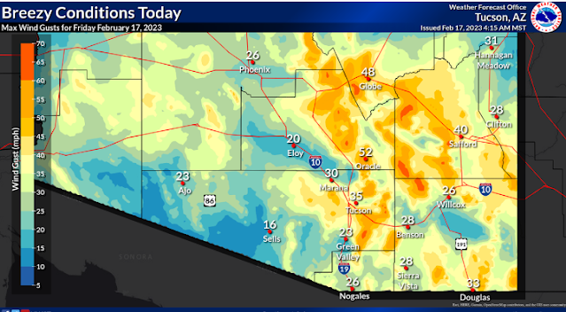
A graphic (above from NWS webpage this morning) shows their forecast for max wind speeds today - note the 52 mph at Oracle and very high speeds at high elevations. Graphic below shows forecast steady speeds from the 12 UTC WRF-RR runs at Atmo - speed at airport forecast to be 31 mph at 10:00 am this morning.
Text forecast for today (above from NWS) indicates chances for blowing dust and windy conditions at the airport today. Observations indicate that the airport has already gusted to 46 mph this morning, while Mt. Hopkins has hit 61 mph. Definitely windy and not "breezy."
Interestingly, the 06 UTC GEFS plumes (above for wind) have considerably under-forecast speeds this morning, but forecast quite strong winds on Sunday, the 12th. The plumes for QPF at the airport (below) indicate chances for rain and showers beginning Sunday and continuing into next week.


No comments:
Post a Comment