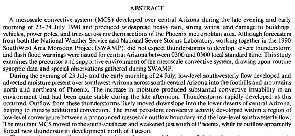
First, I want to point out that similar events have occurred before. Darren McCollum (forecaster at Flagstaff) studied an event (July 23/24, 1990) that began with a late night MCS over the Phoenix metro area, followed by development of a second MCS over the Tucson area around sunrise. Both metro areas received rains of 4 inches or more during the storms. In the Tucson area there were over 50 high water rescues and 1 flood fatality. The Abstract from the paper reporting results of Darren's MS research work is:
The reference for this paper is: McCollum et al., 1995: Case Study of a Severe Mesoscale Convective System in Central Arizona. Weather and Forecasting, September issue - available at AMS web site.
As for the event this week, the upper-air charts show that any large-scale forcing for vertical motion was very weak. The only hint that such forcing was present is in difluent flow in the upper-troposphere. There were, however, several weak outflows providing low-level convergence across much of eastern Pima County. The largest of these was from the Phoenix MCS. The surface observations from TUS, DM, and other nearby stations indicate that there may also have been weaker outflows from the southeast and also the west that also moved into eastern Pima County. None of these features had strong or obvious signatures by the time they reached the metro area, and more careful analysis of the surface data is needed. I hope to also access MesoWest surface plots for the period of the event.
However, the thermodynamic setting by sunrise on the 8th was very potent - 12 UTC sounding from TWC is below.

There is a fair amount of CIN for the 50 mb mixed parcel shown on the Univ. of Wyoming skewT plot. However, the parcel at 850 mb has almost no CIN, if lifted to saturation. Further, there is a shallow layer above 800 mb which appears to be a Moist Absolute Unstable Layer (MAUL). The relevant reference here is: Bryan and Fritsch, 2000: Moist Absolute Instability: The Sixth Static Stability State. Bull. Amer. Meteor. Soc., June issue - also available at the AMS web site. Thus, deep convection appears to have been likely given only the slightest of forcing.

The WRF-GFS (both from midnight and 12 UTC) forecast the thermodynamics very well - forecast sounding for TWC valid at 6 am on the 8th is shown above. The forecast has developed a MAUL centered at about 800 mb, with no convective inhibition present. The model also forecast the outflow (10-m winds below) from the Phoenix MCS to be into the metro area at 6 am.
So one of the key issues that need to be researched are just exactly how, and why, do such MAULS sometimes develop during the night over southern Arizona? I have noted this happening a number of times during the past several summers and have mentioned it here on the blog before. Hopefully, I'll find time to do a more careful examination of the record flood event we're now cleaning up from.

No comments:
Post a Comment