


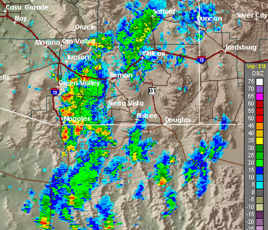
I snipped portions of the WRF-NAM forecasts and also the NWS HRRR model forecasts - all valid at 3:00 pm MST this afternoon - and show them here, along with the actual radar composite chart from 3:00 pm (just below). The three forecasts above are the WRF-NAM forecasts from 00 UTC, 06 UTC, and 12 UTC this morning (in order from top to just above). Below the radar chart are forecasts for 3:00 pm from the 12 UTC and 18 UTC NWS HRRR model runs. Interestingly, the WRF forecast from 00 UTC appears closest to reality of all 5 forecasts shown. The 06 UTC WRF had too little activity, while the 12 UTC run had considerably too much activity.
All the WRF-NAM forecast runs appear, to me, to be superior to the HRRR forecasts - substantially so.
While this is a simple, subjective comparison, it does illustrate the difficulties involved when so many high time and space resolution forecasts are available to the forecaster. The activity is clearly increasing this afternoon and it will be interesting to see if the morning WRF-NAM forecast ends up being off a bit in time. The values of CAPE and PW have been increasing steadily since 12 UTC this morning and all the model forecasts did indicate this trend (PW from GPS estimates is now over 1.4 inches).


No comments:
Post a Comment