Friday, February 28, 2020

Model Forecasts Bring Showers To Start March


Heavy, undulating clouds overhead this morning at about 7:30 am MST. The stream of clouds is being generated by a broad cyclone west of southern California (IR satellite image below from 6:51 am). The moisture and clouds are very high (above 500 mb) and low-levels are very dry - thus, little chance for sprinkles today. The system that threatens to bring shows to start March is captured in the satellite view off west of Washington state.


The 500 mb forecast above (from 06 UTC GFS valid at 5:00 am this morning) shows both the southern and northern systems. By around noon on Monday the northern system dominates, and is forecast to be centered nearly over Yuma (below).


The GEFS ensemble forecasts from 06 UTC this morning are clustered tightly, all but one member forecast measurable rainfall at airport during the day Monday, with average amount over a tenth of an inch. Current morning NWS forecast shown below. 

Monday is three days out, so considerable uncertainty as to how exactly this event will evolve, but something to follow as February draws to an end with its Leap Year's extra day tomorrow. 


Wednesday, February 26, 2020

Windy Morning Here In Tucson


View of early morning lights of north part of Tucson at a bit after 6:00 am MST today. Most weather attention today is focused on the developing storm in the northeast U.S. - image at bottom is of a snowy morning in Indianapolis.


Looks like rest of February will be dry, but it is quite windy in parts of town this early morning - chilly east wind of 20 to 30 mph here at house. Winds at 10-m (from 06 UTC WRF-GFS forecast) above are valid at 10:00 am this morning. Winds at airport yesterday gusted to 33 mph from the north-northwest; similar today, but from the east. Forecast sounding below from the same model run is for Sonoita at 10:00 am this morning - strong winds below 700 mb have already led to gusts to 46 mph at Mt. Hopkins RAWS site early this morning.


Sunday, February 23, 2020

Quick Look At Yesterday's Event


Altocumulus drifting over Catalinas this morning. Quick look at ALERT measurements for yesterday's precipitation event below.


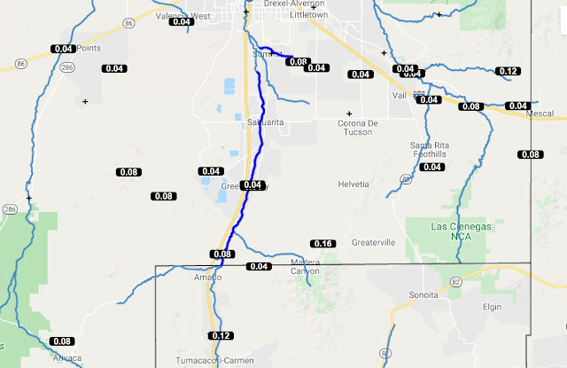
Above figures show ALERT amounts for 24-hours ending 7:30 am this morning. Very light amounts except on northern parts of Catalinas (only 0.03" inches here). ALERT maps below show event precipitation - most of the event was over by yesterday morning. During early morning hours here we had 0.30" - making total event here 0.33". Monthly total here now 0.77".


Saturday, February 22, 2020

Quick Update


Heavy clouds over the Catalinas a bit before 8:00 am this morning. Currently light rain here at house with 0.30" in gauge. Rain here began after midnight.


Composite radar image above (from 7:54 am) indicates heavier rain currently over northwest portion of area - particularly from Marana toward Oracle.


Amounts measured across ALERT network (above and below) through 7:15 am - rain up on Catalinas, with some amounts from half to over an inch so far.


Morning 500 mb analysis shows 500 mb closed low west of LA. System forecast to move across Arizona and Utah during next 24-hours, bringing more rain to our area today. Forecast below of total precipitation amounts through midnight tonight is from the 00 UTC WRF-GFS forecast at Atmo. Looks to be a bit conservative, since amounts above over the metro area have already been reached. Later WRF forecasts appear to have been delayed. Regardless, our second rain event for February well underway here at house is most welcome.


Thursday, February 20, 2020

Second Weather Event Of February Looms


Snowy afternoon in the Ben Nevis Range of the Scottish Highlands - above. Locally, it appears that our second precipitation event of February is developing for Friday night and Saturday.


These three forecasts are from the 06 UTC run of the WRF-GFS model at Atmo. Above is a forecast for the 500 mb level valid at midnight on Saturday. Cold, closed low centered over northwestern Arizona forecast for that time. Forecast skew-T plot below for Tucson at noon on Saturday - PW has increased in the forecast to 30 mm (from current value of a bit less than 10 mm), with a bit of low-level CAPE. Second below is forecast for precipitation amounts through 5:00 am MST on Sunday morning, the 23rd. This, if forecast verifies, would be a significant event for much of Arizona, including the Tucson metro area.


The bottom three forecasts are from the 06 UTC GEFS forecasts. The wind speed plumes above indicated strong and gusty winds ahead of the system on Friday and then again on Saturday during the precipitation. 

Plumes below also show a large jump in PW beginning this afternoon and peaking during the morning on Saturday. The GEFS forecast for QPF at the airport (bottom) indicate a very focussed event lasting from around 5:00 pm tomorrow through 5:00 pm on Saturday. The GEFS forecasts may be a bit faster than the WRF-GFS forecasts, but it should be an interesting start to the weekend, weatherwise.


Wednesday, February 19, 2020

Dreary Morning Here


Dreary start to the day here - as per image above from about 8:15 am MST. Visible satellite image below from 8:00 am shows the cloud cover affecting parts of Arizona.

Although current morning forecast from NWS is for "mostly sunny" today, the forecast discussion (below) describes things more accurately.

.DISCUSSION...IR satellite imagery depicted mainly cirriform clouds  
  extending from southern Arizona southward across Sonora Mexico, and  
  southwestward to well west of Baja California. Mostly cloudy to  
  cloud skies this morning, then clearing from west-to-east this  
  afternoon...

Monday, February 17, 2020

Mild Week Ahead


Clear skies prevail here in Tucson this Presidents Day holiday (above).  Below is view of sunrise at Cabo San Lucas.

Images down at bottom show Yosemite Falls yesterday afternoon, and sunrise from Mt. Wilson Observatory  this morning (both in California).


Models forecast a mild week for us here in southeastern Arizona. Forecast above is for temperatures - highs through Friday around 70 and then cooling begins as next weather system approaches. The QPF plumes below indicate slight chance of showers next Saturday.

Enjoy the beautiful week ahead.


Wednesday, February 12, 2020

Period Of Fair Weather Ahead


Some fog and stratus along the foothills at sunrise this morning.

Below is photo of garupel that Katie took yesterday at the Refugee Welcome Center - near Kino and I-10 north of airport. Nothing like that here at the house.


Rain amounts yesterday were generally light except for a couple of higher amounts near where the graupel storm was, plus an outlier of 0.67" at Corona de Tucson. Other notable 48-hour amounts were 0.83" at Nogales; 0.63" at Pioneer Airfield west of Sierra Vista; and 0.48" at DM AFB. Here at house we had total of 0.34" for the storm. Looks like coming week will be fair and mild, with highs back into the low 70s for end of week and weekend.


I have wondered why there were always so many elk in this webcam view on Jack Hales' webcam wall. A closer look revealed to me that it is at the National Elk Refuge, northeast of Jackson, Wyoming (below).

Tuesday, February 11, 2020

Rainy Afternoon And Evening Yesterday


Kitt peak above - south view - shows some new snowfall out there.

At bottom (1st image) moon hangs over Denver; view from Denver Museum of Nature & Science. Have been there many times and recommend it highly. Second image at bottom shows sunrise at Hermosilla, Mexico, this morning.


Nice rain event yesterday afternoon and evening. Amounts from ALERT (above and below) are for 24-hours ending at 6:00 am MST this morning. Here at house we had total of 0.32". Rains generally ended before midnight.


There was considerable thunderstorm activity over Arizona and southwest New Mexico (plot of detected CG flashes through midnight above - from ATMO and Vaisala). Here at house there was a flash and crash of thunder at 3:40 pm in the afternoon.

Latest radar (from 7:05 am) shows another band of showers moving into northwest parts of the metro area.