Monday, June 27, 2022

Rain In The Gauge!


Heavy clouds over the metro area this morning, and perhaps a few lingering sprinkles around.

Plot of detected CG flashes for 24-hours ending at 1203 UTC this morning (from Atmo and Vaisala) shows that thunderstorms mostly avoided eastern Pima County during the period.

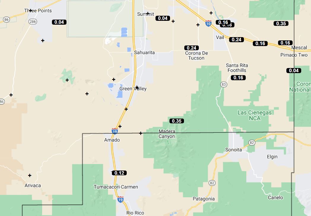
However, light showers crossed our area during the early morning hours today. The ALERT reports (above and below), indicate that amounts of 0.04" and greater mostly avoided the metro area. But amounts were heavy over the Catalinas - one site reported over two inches.

Plot focused on the metro area (second below, from MesoWest) shows that many spots in the city had light amounts, or a Trace. We had 0.06" around 3:30 am MST this morning - just enough to dampen the soil.


Morning sounding from TWC/TUS (above) shows that PW jumped to over an inch and a half - but, it will be hard for limited heating today to break the strong inversion at 850 mb. Winds were light and variable through most of the troposphere.

Forecast 500 mb level from the 06 UTC GFS (above) shows a weak trough stretcheing from northeastern New Mexico to southeastern Arizona. Anticyclone centers are over Nevada and central Texas - note that TS Celia is well west of southern end of Baja - that storm is moving west and weakening. 

The 12 UTC forecast (below) from the 12 UTC WRF-RR run at Atmo indicates little activity today for all of Pima County, with perhaps some showers on the Catalinas. After a very active day for most of Arizona yesterday (see CG plot above), model forecast indicates much less storm activity today.

Sunday, June 26, 2022

Increased Showers Today


Mostly middle clouds overhead this morning.

Plot of detected CG flashes (above - from Atmo and Vaisala) is for 24-hours ending at 0830 UTC this early morning. Very little thunderstorm activity across all of southeastern Arizona yesterday, as main activity was in a band from Sonora northward across western Arizona. There were a couple of severe wind reports with this band.

Precipitation (below) was extremely limited across the ALERT network with only 9 reports of rainfall, and the entire metro area very suppressed. Still waiting for meaningful rain in my gauge.


The 500 mb pattern (above) remains similar to yesterday, but with weak trough from from near Four Corners to northern Baja that will shift a bit eastward during the day today. The morning TWC sounding (below) is also very similar to yesterday's.


The 12 UTC WRF-RR forecasts a significant increase in storm activity today over eastern Pima and Santa Cruz Counties (radar echoes above forecast for 5:30 pm this afternoon). Rain is also forecast by the model across Tucson Metro, with a tenth of an inch at the airport (below for period ending at midnight tonight).

The NWS morning forecast is shown  second below, with 60 percent POPs indicated for the airport this afternoon.


Saturday, June 25, 2022

Down Day Here Yesterday


Heavy cloud cover over metro and Catalinas a bit after sunrise this morning.

Graphic this morning on NWS webpage (above) focuses on lightning safety - a good graphic that I don't recall seeing before. It's important because the two most significant weather hazards here in southeast Arizona are lightning and flash floods.

Plot of detected CG flashes below is for 24-hours ending at 5:03 am MST this morning. Note that storms avoided much of the Tucson area. There was thunder and Trace of rain reported at both the airport and DM (also gust to 38 mph at the AFB). 


ALERT plots (above and below) are for 24-hour rainfall ending at 7:00 am this morning - only 25 scattered sites reported 0.04" or more, with max amounts on the Catalinas.


This morning's 500 mb analysis (above) shows light and variable winds over the Southwest, with the large anticyclone center over southern Arkansas. Band of higher RH at this level covers eastern Arizona and much of New Mexico.


This morning's sounding is much like yesterday's with fairly dry air below 700 mb, little CAPE, and light/variable winds below about 450 mb. The 12 UTC WRF-RR forecast for rainfall through midnight tonight (below) indicates only some spotty light showers for eastern Pima County. Note that yesterday's WRF-RR forecast verified quite well (see previous post).

Friday, June 24, 2022

More Scattered Showers


Heavy storm over the Catalinas yesterday afternoon about 2:30 pm MST.


Plot of detected CG flashes (from Atmo and Vaisala) for 24-hours through 1:30 am this morning - limited activity over Tucson area, but not quite a classic donut hole. Reports from the ALERT network of 24-hour rainfall (two plots below) through 8:00 am this morning indicate limited areal coverage of mostly light showers (four sites with over half an inch). Nothing in the gauge here yet again.


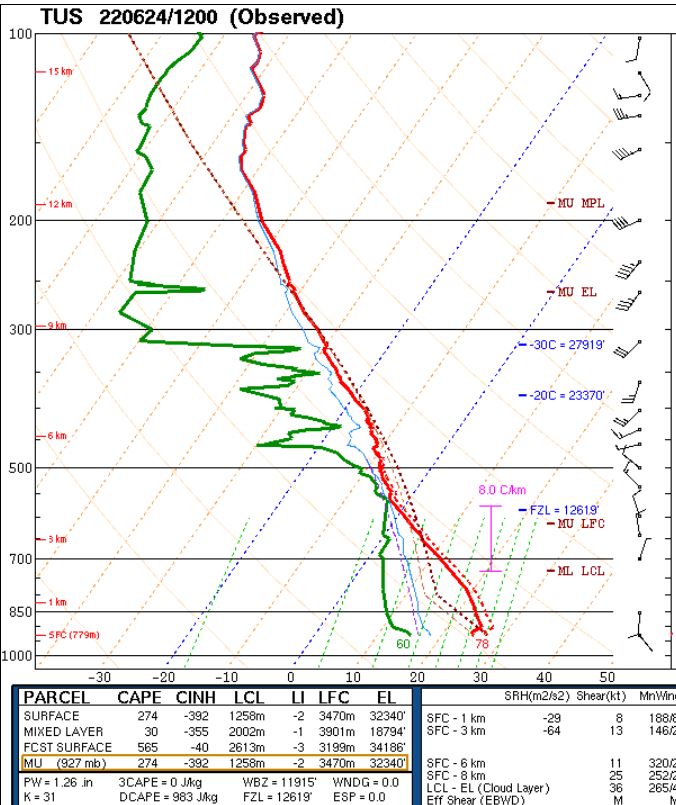
The 500 mb analysis this morning (above - ignore the bad analysis of a closed low to our east) indicates a weak trough from Four Corners region south to end of Baja. The TWC/TUS morning sounding (below) is quite a mess. There are signals of the influence of mesoscale downdrafts, little CAPE, some middle level moisture, and a chopped-up wind profile below 400 mb. I'm hard pressed to find anything good to say, but can hope that there might be some improvements during the day.


Two graphics here from Atmo's WRF runs to look ahead for this afternoon. Forecast above is from the 12 UTC WRF-RR and shows CAPE at 6:00 pm being very small in our area. Forecast below is for rainfall through midnight tonight (from the 06 UTC WRF-GFS - 12 UTC WRF-RR is very similar). So, the models predict another day with widely scattered storms, but not much in the way of significant rainfall.

Wednesday, June 22, 2022

Rains Close By Yesterday


View of Catalinas yesterday afternoon at a bit before 3:00 pm MST - thunderstorms stayed mostly to east and south of metro area.

ALERT plots for 24-hours ending at 7:00 am this morning. Cluster of reports from sites near Redington Pass and also scattered reports across south half of network, with most reports being quite light. Nothing here at the house except for a couple of gusty outflows. Airport reported thunder and Trace with gusts to 36 mph during the afternoon. All-in-all a pretty bland day with respect to the forecasts for an active day (see previous post).


Plot of detected CG flashes for 24-hours ending at 1400 UTC (7:00 am) this morning (above, from Atmo and Visala) shows the storm activity from yesterday afternoon, as well as some unusual, early morning storms near Yuma - thunderstorms are even occurring over the south part of California this morning!

The morning 500 mb analysis (above) shows a weak closed low along California coast and a trough eastward across Arizona. The large anticyclone over central US has no well-defined circulation center this morning.

The morning TWC/TUS sounding plot (below) has moistened considerably  below 700 mb compared to yesterday (see previous post) and there is a fair amount of CAPE. Winds are light and variable below 400 mb, so there is no distinct steering flow.

The 12 UTC WRF-RR forecast verified reasonably well for Pima County yesterday, and I grabbed its forecast of precipitation through midnight - second below. Even though the sounding looks favorable, the model again keeps the storm activity fairly restricted and mostly in Cochise County. I would expect a more active day, especially over and near the mountains - time will tell.


Tuesday, June 21, 2022

Difficult Forecast Today

Middle cloudiness over the Catalinas and metro area this morning, a bit before 8:00 am MST.


This morning's 500 mb analysis (above from NCAR RAP)  shows the anticyclone still centered far to our east over the Missouri Bootheel. A massive ridge extends from Hudson Bay southward to central Mexico. Most of the trough that was to our northwest has pulled away to the northern Plains, leaving a weak piece of trough over central California.


The morning sounding from TWC/TUS (above) shows increased middle-level moisture, but the layer below 650 mb remains quite dry, with PW a bit below an inch. The sounding has only a hint of CAPE, and low level moisture will have to increase considerably to support widespread thunderstorm activity this afternoon. The 06 UTC GEFS plumes for CAPE (below) indicate only slight CAPE this afternoon and tonight.

Forecasts here from the 06 UTC run of the WRF-GFS (above) and from the 12 UTC WRF-RR (below). The WRF-RR forecasts considerably lighter amounts across eastern Arizona than does the earlier WRF-GFS. Based on the morning sounding, I would tend toward the WRF-RR and expect light showers across eastern Pima County, with limited thunderstorm activity this afternoon.

Current NWS morning weather story is second below, and is more similar to the WRF-GFS forecast for eastern Arizona. It's a tough forecast today and the weather outcome will depend on how much CAPE actually develops - really hurts not to have a morning Guaymas sounding!


Monday, June 20, 2022

Showers Tomorrow?


Nice morning here in Tucson with a bit of cloudiness to the east and northeast.

Storm activity stayed east of the metro area yesterday, as per the plot of detected CG flashes (below - from Atmo and Vaisala) through 0803 UTC early this morning. The WRF precipitation forecast shown in yesterday's post verified quite well, even picking up the activity activity at the south end of the Rincons. Precipitation reports were mostly in Cochise County. There were two ALERT sites with 0.04" in the southeast corner of the network. Most precipitation reported, that I found, was at Safford with 0.31".


This morning's TWC sounding plot (above) shows dry low-levels and no CAPE. However, models are forecasting increased moisture and PW moving northward into southeast Arizona late today into tomorrow. Precipitation forecasts from the 1200 UTC run of the WRF-RR indicate some rainfall today - mostly east to south of our area (below).


However, tomorrow a weak short-wave at 500 mb is forecast to move northward across Arizona - forecast above valid at 5:00 pm MST tomorrow afternoon is from the 06 UTC run of the GFS. The short-wave helps spread the forecast rainfall to the west, covering almost all of Pima county by midnight tomorrow (below from same WRF-RR run at Atmo run).

Ground here is bone dry and I have to water every other day to keep plants going. Really hoping for a meaningful rainfall soon.