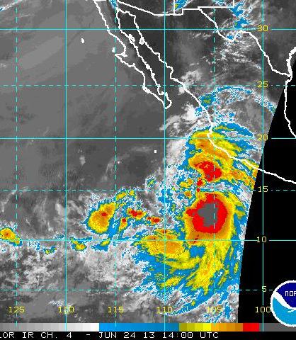
Tropical Storm Cosme is located off the southwest coast of Mexico this morning and the NHC intensity estimate is that it has maximum winds of about 50 mph. The current image above is IR from 1400 UTC and image below is visible from 1430 UTC. Cosme has a large cloud shield associated with it that extends north along the coast past Puerto Vallarta.


The current NHC forecast for Cosme (above) is that will strengthen to become a hurricane, while tracking west-northwestward. The forecast track keeps it a bit too far southwest of lower Baja to create a significant, deep surge of tropical air up the GoC. This morning's NAM forecast indicates that the large size of the Cosme circulation will, however, produce strong winds and some convection over the southern third of the GoC. The graphic below is the NAM forecast of 10 m winds and precipitation valid at 5 pm MST on Wednesday. The key question is, assuming this forecast is reasonably accurate, what will the impacts, if any, be for southern Arizona? My current guess is that there would be enough disturbance over the lower GoC to initiate a surge of mT air northward. This surge would likely be shallow (coming into southwest Arizona late Wednesday or Thursday morning) and quickly mix out, given the brutal heat expected at the end of this week.

No comments:
Post a Comment