As per the quite good WRF model forecasts at various times yesterday, there was indeed another upswing in thunderstorm activity yesterday - giving us four days now of an alternating up/down cycle. View above of Catalinas, from a drippy campus, shows how high-based the storms were. The 00 UTC sounding from TWC (below) was taken just before a strong outflow moved across metro area from the south (TUS had a high of 105 F a bit before 4:00 pm MST). The strong heating was an important aspect of yesterdays's storm environment, as the lack of coherent winds in the troposphere continued. The detected CG flashes (second below, from Vaisala and Atmo) through midnight last night show the marked increase relative to Friday and that the storms in the hot environment were fairly prolific lightning producers.
A storm did drift in from the north here at the house yesterday afternoon, but produced only 0.06". Over the ALERT network 26 sites had rain (0.04" or more) between 5 am and 5 pm; between 5 pm and 5 am this morning 24 sites had rain; and for the 24-hour period 37 sites had rainfall. However, amounts from the high-based showers were generally light - only 10 sites had a quarter of an inch or more and just 4 sites had over half an inch. The storms did produce downbursts between here and the Phoenix metro area - reports at SPC included: power poles down near Picture Rocks and also up in Mesa; wind damage reports from near Florence, San Tan and Ahwatukee.
The morning 12 UTC 500 mb analysis (above from NCAR RAL) shows the anticyclone centered over the White Mountains , with light winds over much of the Southwest. However, the west coast trough will increasingly dominate during the coming week, as September begins. Ups and downs in daily activity will continue; however, the wild card at play is the possibility of a tropical storm near or west of Baja by next weekend, This forecast feature in the global models ranges from being in the GoC to fairly far west of Baja - just something to keep in mind as the week evolves.
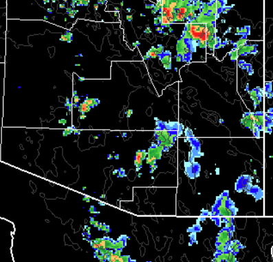
This mornings sounding from TWC - below - continues little changed. No winds and CAPE down slightly, with PW continuing fairly steady. Shown at the bottom are two WRF-NAM forecasts of composite radar echoes. Top is from the 00 UTC run and bottom is from the 06 UTC run - both are valid at 6:00 pm MST late this afternoon. Main thing of note is that the models forecast another downturn for today, with only isolated storms over eastern Pima County. So, Mike's discussion re the new morning runs of the models will be of interest again today.


No comments:
Post a Comment