Thunderstorms occurred over much of the Tucson metro area during the late night and again before sunrise. Image above shows lightning over the Catalinas at 4:40 am MST. Photo below is of a morning rainbow taken from house at 5:45 am. Down at bottom is 5:40 am view to the west from downtown, showing a faint, secondary rainbow.
A fairly large MCS developed over southern Arizona by sunrise and moved off toward the Phoenix area. Satellite IR image of system (above at 6:18 am) from NCAR RAL. Below shows composite radar at 6:22 am - also from NCAR RAL.
Plot of detected CG flashes (above for 24-hours ending at 1303 UTC - from Atmo and Vaisala) indicates two periods of CG flashes over eastern Pima County - takes a close look to see this. Heavy storm activity indicated over Pinal County around sunrise. Some reports around Casa Grande were approaching 2 inches.
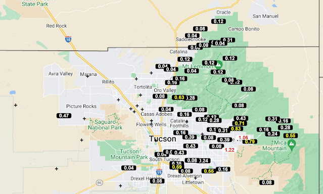
The ALERT plots for 24-hours ending at 6:00 am (below) show that about 80 percent of the sites recorded 0.04" or more rainfall. Note two reports over an inch off toward Redington Pass. Detailed time series plots (from both ALERT and MesoWest) indicate that many sites had rain before midnight and again during the early morning hours. For example: TUS reported 0.18" from 9:00 pm to 10:34 am and then .03" between 4:00 am and 6:00 am. Here at house we had 0.19" which all fell around 4:00 am to 5:30 am.
The morning sounding from TWC/TUS (above - from SPC) is quite moist, with some CAPE and mostly light and variable winds. Sounding was released during the early am rainy period and is likely not representative of the background environment. Would certainly be a good day for a special sounding around noon.
The 12 UTC run of the WRF-RR model forecasts only light showers today for most of the metro area (plot above shows rainfall through midnight tonight). Below is NWS Forecast Office current forecast for airport, indicating high POPs and a Flash Flood Watch in effect through next Tuesday. Quite an active period - will be interesting to watch what actually transpires.


No comments:
Post a Comment