Monday, May 27, 2013
Upper-Midwest Evaluation
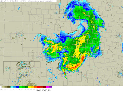
This post refers back to the one on Friday morning, 24 May 2013. This Memorial Day morning there was a large MCS centered over southwestern Iowa at 1115 UTC as per above IR satellite image. The 1201 UTC regional radar is shown below. Nothing of significance over Wisconsin, and strongest storms north of Kansas City.
The 24-h NAM forecast of 12-hour total rainfall valid at 12 UTC is shown above, and the forecast NAM radar echoes at 12 UTC are below. The model still was forecasting significant storms over Wisconsin and was not very good at 24 hours. This illustrates nicely that, while the models are much improved, convective storms, especially nocturnal MCSs, remain as a difficult forecast problem.
The NWS watch and warning map from 12 UTC this morning is shown below. Red indicates flash warnings; light green indicates flood warnings; and dark green indicates a flood watch. The light pink is a severe thunderstorm watch. The NAM 72-h forecast, shown in the earlier post, did the best wrt to forecasting the observed convective system but forecast way too much activity over Wisconsin and Illinois. The Des Moines NWS Forecast Office provided best forecasts and discussion among the three stations I looked at on Friday.
Subscribe to:
Post Comments (Atom)


No comments:
Post a Comment