Wednesday, July 24, 2013
Difficult Situation Today - 24 July
Yesterday was another suppressed day for much of southern Arizona, with storm activity mostly east toward New Mexico - above plot shows lightning strikes for 24-hours ending at 6 am MST this morning. Across the ALERT network only 1 site had light rainfall (1% areal coverage). Still waiting for the first meaningful rain of summer (say 0.25" or more) here at the house, making this a very bad start to the monsoon season here in north part of town.
This morning the larger-scale setting has become a bit more interesting, as winds in middle-levels have increased and an inverted trough at 500 mb has sharpened some. The chart above is the NAM 500 mb analysis for 12 UTC this morning. The large anticyclone has at least two centers of circulation - one is over northeast New Mexico and the other is over California, south of San Francisco. The inverted trough has become more pronounced between these two features. The NAM forecasts little movement, other than an elongation to the northeast across New Mexico, of the inverted trough, as it remains stuck between the two anticyclone centers through 24-hours. So it appears that northeasterly steering winds will remain at about 20 kts or so today.
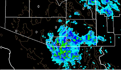
PW remains high but middle level temperatures remain warm - so best CAPE occurs over higher elevations again. The early WRF-GFS forecasts an upturn in thunderstorm activity for southeast Arizona today. The model keeps PW high through its forecast and also forecasts CAPE to exceed 1500 j/kg early this afternoon at TUS. The model forecast of rainfall through midnight tonight is shown below, with highest amounts forecast north and east of the Catalinas and along the Borderlands.
However, the conditions early this morning may be impacting the model forecast. It forecasts the development of morning storms that move along the Borderlands - the above is model forecast rainfall though noon today. The 10-m winds forecast for 2 pm this afternoon are shown below, indicating a strong outflow from the morning storms moving northward across eastern Pima County. This ouflow then affects the evolution of storms during the rest of the afternoon. This morning there is heavy middle cloud across most of southeast Arizona, and the model may have forecast too much heating over Pima County by mid-day. There are, however, currently some showers indicated by radar near Benson and also east of Nogales - so the early WRF-GFS can't be completely discounted at this time. But, a check of the morning WRF forecasts will certainly be needed once those forecasts become available.
Subscribe to:
Post Comments (Atom)


No comments:
Post a Comment