Thursday, December 31, 2020

Stormy End Of Year For Much Of Country

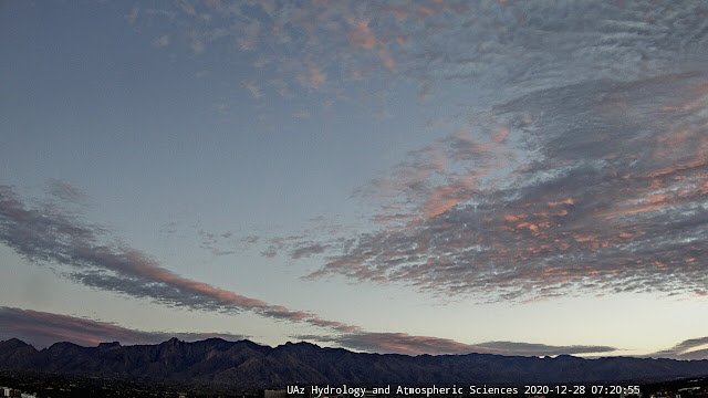
Mostly clear skies over Tucson and the western portions of the Catalinas this morning at 8:15 am MST. Down at bottom is view of a slightly skewed snow stake at Forest Lake, Arizona (along RIM west of Heber), where there is a bit of snow cover.

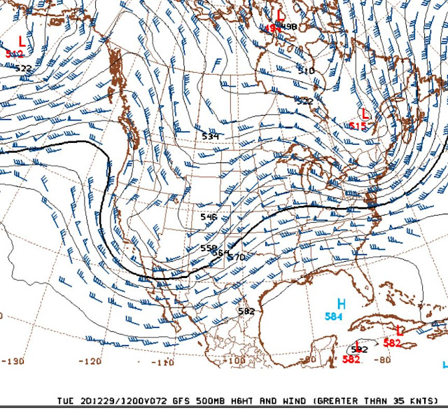
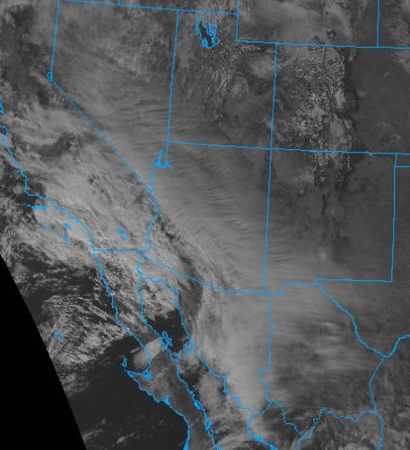
The 500 mb chart for 12 UTC this morning (above) shows a large closed low over northeastern Mexico - this system is bringing nasty weather to much of Texas this morning - both heavy rains and snow. Note that another short-wave trough is over California and Nevada - this feature is digging toward Arizona, but is extremely moisture-starved. The two GFS 500 mb forecasts below are valid at 5:00 pm today and at 5:00 pm on New Years Day tomorrow. Too bad that the trailing feature is so dry. Although the 1320 UTC IR image (third below) shows that there is a fairly large shield of high cloudiness with the second system that may bring us periods of clouds today and tonight.


This morning's hazards  map for the US (above) shows a variety of stormy weather on-tap for much of the northwest and south-central parts of the country. The dark gray areas over Arizona indicate poor air quality.

Finally, I show two interesting, 12 UTC sounding plots from this morning, associated with the Mexican closed low. Above is at Chihuahua, Mexico, and indicates a substantial snow event underway. However, the sounding below (from Del Rio, Texas) has a warm layer (> 0 C) from 850 to 700 mb - this would likely melt the snow falling from above. However, below the warm layer is cold layer extending down almost to the surface. This cold layer has the potential to freeze rain drops falling from above, producing sleet (now called ice pellets) at the surface. Don't know exactly what fell down there but there were NWS statements warning of sleet as well as a wintry mix of snow, ice, and rain. 


Record Setting Year Coming To An End


John Glueck at the NWS Forecast Office has posted an extremely comprehensive review of 2020 at the NWS website today, See:


The summary graphic at top is just a small part of what's posted at the link above. Of note is the extreme warmth and dryness of the year just ended. I'll take a look at the past year here at the house in tomorrow's post.


The outlooks for January 2021 from the NWS Climate Prediction Center (above Temperature and below Precipitation) indicate more of the same, as we begin a new weather year here in Tucson.


Tuesday, December 29, 2020

Few Sprinkles Here


View of Catalinas and north part of Tucson above at 7:10 am MST this early morning, showing heavy clouds overhead. Skies now are clearing with bright sunshine. Here at house there has apparently been a light sprinkle, since the newspaper had a few drops on it when I brought it in. Down at the bottom are views of clouds massing on Kitt Peak and also of sunset colors yesterday evening.

Only a few sites in the northwest part of metro have reported measurable rain as of about 8:00 am -  below from MesoWest. There was a skiff of light snow in Summerhaven this morning. 

All in all not much of an event, other than yesterday's strong winds. Almost all the observing sites in southeast Arizona reported wind gusts over 30 mph yesterday afternoon. Guthrie RAWS and Pioneer Airfield had gusts to 51 mph; Empire RAWS had 44 mph; TUS and Marana had 41 mph; and Canelo RAWS reported 40 mph.


The 06 UTC GEFS plumes for QPF at the airport (above) indicate light showers through the day. However, both the 06 UTC WRF forecasts below (top GFS version and second RR version for total precipitation through noon tomorrow) indicate that the event has basically ended for most of the greater Tucson area. Up to this time none of the model forecasts for last couple of days have handled this event very well.


Monday, December 28, 2020

Chance For Showers Tonight And Tomorrow

Bit of color before sunrise this morning. Down at bottom are views of Catalinas yesterday, and of stacked lenticular clouds downwind of Mt. Rainier in Washington.

The large, closed low at 500 mb off California is forecast to open up and shear to the northeast as it comes across the Southwest. Above is 500 forecast, valid at 7:00 am on the 30th, from the 06 UTC WRF GFS run at Atmo. Note the very cold temperatures, approaching -30 C, as trough crosses Arizona.


Numerous hazards across US next 24 hours (above) associated with the trough: pink areas have winter storm warnings , purple areas are under winter weather advisories, and dark brown area over Arizona is a strong wind advisory. See weather.gov for additional details.

The 06 UTC WRF GFS forecast for 10-m winds, below valid at 2:00 pm MST today, shows the strong winds forecast for Rim Country and northeast Arizona, but also forecasts equally strong, mountain-associated, winds here in southeastern Arizona.

The QPF plumes for rainfall at the airport, also from 06 UTC, above indicate nearly 100 percent chances for measurable rain at the airport tonight and tomorrow. As for precipitation with the system, the same WRF nighttime run forecasts light rain and mountain snow over much of eastern Pima County (below), but nothing at the airport. That forecast also indicates very cold temperatures across metro area for the morning of Wednesday the 30th, second below - valid at 7:00 am. So considerable changes in store next couple of days.


Saturday, December 26, 2020

Fair Skies Return

Skies cleared from the west yesterday after the morning showers - we had a hundreth here, as did a few other spots around the metro. Looks like there will be one more chance for precipitation before the year ends.


The forecast above is from the 12 UTC GFS forecast this morning and is valid at 12 UTC on Tuesday morning, the 29th. The large trough over the Southwest will bring winds and a chance of showers.
The GEFS plumes here are from 06 UTC. The strong winds (above) on the 28th are ahead of the trough, followed by chances for showers on Tuesday morning (below). The spread is fairly substantial though, with some members forecasting no precipitation and one member forecasting over half an inch. Regardless, something to watch as 2020 draws to an end.

Friday, December 25, 2020

Christmas Morning

The flight misery map above shows that Christmas day travellers have pretty good going, except in the stormy Northeast.

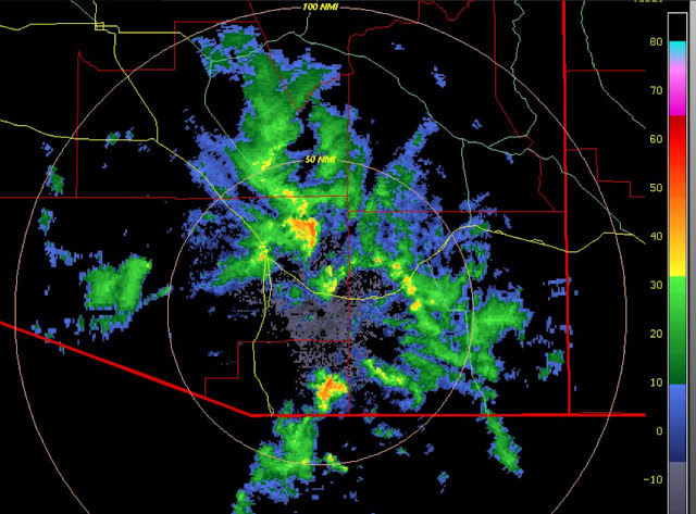
Radar echoes this morning - there have been isolated showers moving across the metro area. Shower here was enough to wet the courtyard flagstone, but left only a trace in the gauge. Above shows second tilt KEMX echoes from CoD radar page. Below is new NWS radar display - I'm not particularly fond of this change as of now - time will tell. It is also handicapped by the tiny legend that displays down at bottom left of the image.


Some Christmas colors this morning from Jack Hales' webcam page. Above is Cooke City, Montana, just north of Yellowstone NP. Below are the light pylons at LAX.


Sunrise behind the Tetons from Alpine, Wyoming, above, and green vehicle lights on Salt Pass Highway 89 south of Afton, Wyoming.

Thursday, December 24, 2020

Dreary Skies For Christmas Eve

Gray and dreary skies for Christmas Eve here in Tucson. Here at the house the morning low fell to 26 F, before the clouds moved in. Winds this afternoon here are nearly calm, but strong east-southeast winds have been blowing since 9:00 am MST this morning at the airport, with max gusts in the upper 30 mph range. So, yesterday's WRF forecast (see previous post) was far superior to the GEFS wind plumes.

Overcast skies seen from satellite here: upper-level water vapor image above from 8:00 am and visible image from 2:25 pm below.


Solar radiation time series from Atmo above, and unwrapped sky cam from Mt. Lemmon below at 2:25 pm. All-in-all a very gray day.
 

Wednesday, December 23, 2020

Dry But With Some Winds

View of Catalinas before sunrise shows high, thin clouds overhead this morning. The cirrus is coming in off the Pacific from weak disturbance west of southern California and Baja, as per IR below from 7:50 am MST.

The 06 UTC forecast from the WRF-GFS at Atmo (above) indicates a windy day for Christmas Eve - wind forecast above is valid at 9:00 am tomorrow morning.

Plumes from the GEFS at 06 UTC last night shown here: QPF above indicating dry until chances for sprinkles near end of year - sprinkles tomorrow now gone from current forecasts; 10-m wind speeds below are much weaker than the WRF forecasts for tomorrow - so will be interesting to observe which model is closer to what happens.

Plume for T indicate slight cooling tomorrow due to a weak front coming by. Rapid warming then until marked cooling next Tuesday and Wednesday.