Mt. Lemmon all sky view at 6:00 am MST this morning - big blur on right is nearly full moon setting.
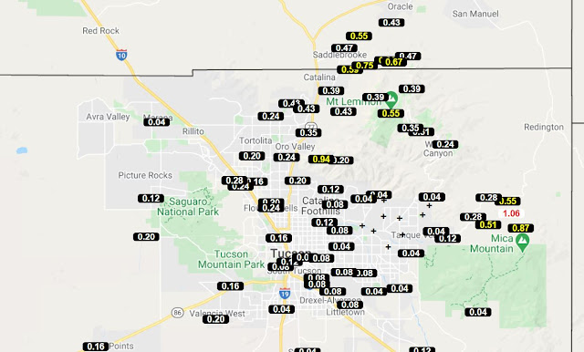
Plots of total rainfall across ALERT network for month of November (north half above and south below). It was a very dry month for most of network, with only rain amounts over half an inch occurring on the mountains. Note that the amount of 0.59" between Mescal and Vail seems quite suspect.
Here at house we had 0.15" of rain on the 9th - which was also the total amount for the Fall (September through November - driest Fall in my records). Soil so dry I'm still having to water some of the yard plants.
During November there were five mornings here with lows of 32F or below - coldest was 26F on the 28th. Low here this first morning of December was 30F.
While I was scanning observations for wind gusts yesterday (highest I found was the 39 mph at the airport), I noted that Kitt Peak winds hit 76 mph (on the 4m catwalk) back on Thanksgiving day. This seems a bit strange, since the only gust recorded at the airport came in at 18 mph.
Forecasts for long-term precipitation (from the 00 UTC run of the GFS model) shown here are for 168 hours above and 240 hours below. The 240 hour forecast finally indicates a chance for rain here - the forecast event occurs entirely on December 10th - over a week out, but something to watch.


No comments:
Post a Comment