Friday, June 29, 2018
Mixed Signals For Today
First - a look at yesterday. Photo above was taken looking southeast from here right before sunset. There were two, stubby little Cbs off in the distance - radar says they were over the north end of the Santa Ritas.
Below is the SPC map of severe thunderstorm reports yesterday. A big storm day from northern Plains all the way to the Gulf Coast with almost 700 reports. Two long-lived MCSs produced severe winds from eastern Nebraska to the Gulf (over 600 severe wind reports yesterday)!
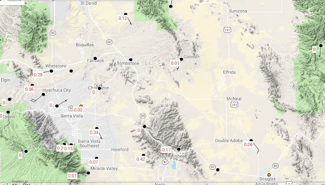
Thunderstorms in Arizona focused on southwest Cochise County with abundant CG flashes (above is 24-hour detected CG flashes thru 1:00 am MST last night, from Atmo and Vaisala). The map below (from MesoWest for 24-hour rainfall ending at 7:00 am this morning) is zoomed on the lightning region - a couple of reports over 2/10s of an inch, but mostly sparse rainfall and wildfire threat.
Now - this morning's situation. The 500 mb analysis for 12 UTC (above from SPC) shows that the California trough is pushing eastward across Arizona and is a more dominant feature than the models forecast a couple of days ago.
The morning skew-T plot of data from TWC (below) shows PW of 1.26" and substantial CAPE - both somewhat surprising (although the jump in PW had been predicted by the GEFS earlier this week), however those forecasts kept the PW high through the Fourth of July here.
The forecast issue for the day is now - will deep convection develop nearby? The forecast models have gone completely dry - the 06 UTC WRF-GFS basically forecasts no rain in Arizona through the Fourth.
Here are two PW forecasts from the 06 UTC WRF-GFS. The forecast above was valid at 5:00 am (TWC sounding time). It appears that the forecast was too dry by about 2/10s of an inch this morning - a significant amount. However, the forecasts move drier air in steadily during the day from the west and forecast below is valid at 6:00 pm this afternoon - an ugly forecast, especially compared to those earlier in week that kept PW high.
So in summary - the morning sounding is very unstable but forecast to change rapidly during the day as warmer and drier air advects in between 700 to 300 mb. The models forecast that this trend will kill storm development in Arizona. However, I tend to feel that we'll at least be able to see storms around this afternoon - especially to east and southeast, even if they aren't hitting here in the metro. A tough and disappointing situation for today.
Subscribe to:
Post Comments (Atom)


No comments:
Post a Comment