Wednesday, June 13, 2018
TS Bud Fading Rapidly
TS Bud is weakening rapidly (IR image above is from 1330 UTC) and currently moving northward very slowly. The NHC morning track forecast of Bud's remnants continues to shift eastward. However, regardless of where old Bud circulation goes, it appears there will a nice, albeit brief, intrusion of high PW, subtropical air into Arizona. Below is MIMIC TPW analysis at 13 UTC this morning. Values over an inch are poking into southwest Arizona; however, very high PW remains south of 30 degrees north.
Note - I seem to have lost access to the Atmo weather products page, so I have no idea how the WRF forecasts are trending.
It does appear that Bud event is trending toward thunderstorms and convection rather than a widespread moderate to heavy rain event.
I've grabbed two SREF plume products from the SPC webpage this morning. Above shows QPF forecasts for TUS (note that horizontal scale lines are at 0.2" intervals above BUT 0.1" intervals below). While six members of the ensemble continue to forecast significant QPF amounts for TUS, the majority of the runs are forecasting less than half an inch - the dry members forecast only a trace to couple of hundredths. So very large range of possible outcomes continues as event draws closer.
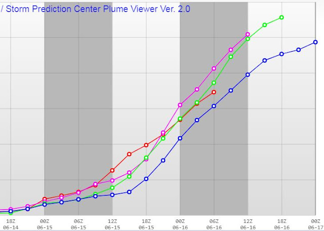
Plot below shows trend of average TUS QPF from last 4 forecast runs (red to purple to green to blue) and are trending drier in last run (09 UTC).
Subscribe to:
Post Comments (Atom)


No comments:
Post a Comment