Note - Yesterday's post did not get on-line, and I just uploaded it this morning.
Heavy clouds over the mountains and metro area at 7:30 am MST today.
The plot of detected CG flashes above (from Atmo and Vaisala) shows eastern Pima County virtually thunderstorm-free through 0733Z this morning. There were light showers over northwestern parts of the Catalinas yesterday. Rainfall was reported at 12 ALERT sites in that area, with one site recording just over half an inch,
The morning 500 mb analysis (above from SPC) shows that whatever short wave passes us from the south today will be very weak (soundings continue missing from TWC and they apparently have a suppy shortage of some kind). However, the WRF model runs at Atmo do develop precipitation this afternoon. The forecast below is from the 09 UTC WRF-HRRR and it puts some amounts over parts of the metro area around half an inch or so.
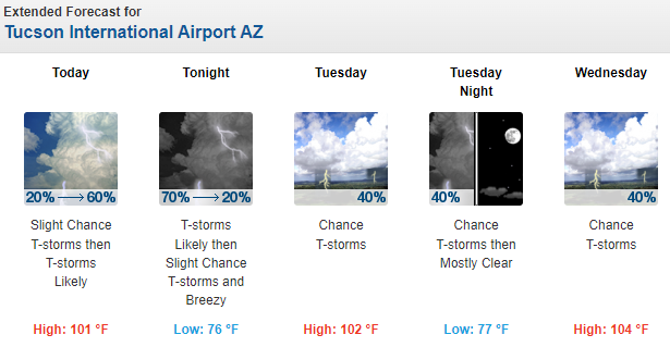
The current NWS Forecast Office products are quite strong on rain today. Above morning graphic for southeast Arizona, and below current forecasts for the airport through Wednesday.
The eastern Pacific is very active and a TS/Hurricane will be moving north somewhere west of Baja by early next week. Where this system actually tracls will determine its impacts on our area.


No comments:
Post a Comment