
 First - yesterday afternoon brought moderate buildups, some virga, some mammatus, some wind and a couple of spits of rain here at house. First Trace observed here since the Trace on May 2nd. Tucson WSR-88D radar remains broken and out of service, so more days with storms in southeast Arizona but no radar documentation of what actually happened.
------------------------------------------------------------------
This morning brought clear skies, very warm temperatures and brisk easterly winds at sunrise (see Diebolt comment in post below). Dewpoints have climbed slowly; the backdoor front came in stronger than I expected; so we have downslope flow affecting the increased low-level moisture that's come from the east to southeast (definitely not from GoC as per Douglas comment below).
------------------------------------------------------------------
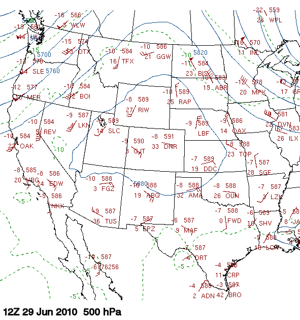
Tucson sounding this morning is somewhat chopped up - warming temperatures at 500 mb compared to yesterday; some increase in low-level moisture (note that sounding remains dry by 3.5 mm vs GPS); and strange west winds at 500 mb. If boundary layer can mix out at 5 g/kg this afternoon there is CAPE somewhat similar to yesterday, perhaps even enough for deeper storms when ice heat of freezing is added. The entire upper-troposphere has westerly flow, and the charts above 400 mb show a pronounced trough entrenched over the west and northwestern Mexico. The 500 mb morning analysis (middle graphic) indicates the anticyclone has shifted north to Wyoming and that there's a smaller scale, cyclonic feature of some kind over Arizona. Basically, winds are L/V and height gradients almost zilch from the Four Corners southward to central Mexico. A pocket of cooler air at 500 mb does remain over Arizona and northwest Mexico, favoring convective development. Although moisture is higher over toward El Paso, the 700 mb flow in the NAM model forecast (bottom panel valid at 06 UTC tonight) just can't seem to get the higher RH west of the Continental Divide, except down in Mexico.
--------------------------------------------------------------------------
What does all this add up to? Assuming the downsloping doesn't continue strong and suppressive all day, then storms should be somewhat similar to yesterday. Mostly on mountains and strongest east to north of Tucson, but with some potential for stronger downburst winds in western portions of the lower deserts. Note - it seems to me that the U of A Atmo runs of the high-res WRF model have done better with downslope events than the NAM. I note that the NAM doesn't forecast much today in the lower elevations, and I don't know what the WRF might be doing.
No comments:
Post a Comment