Wednesday, July 31, 2024

Another Down Day


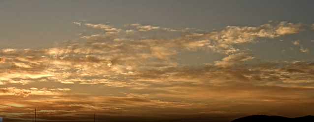
Morning view at 5:40 am MST looking toward Rincons and Redington Pass.


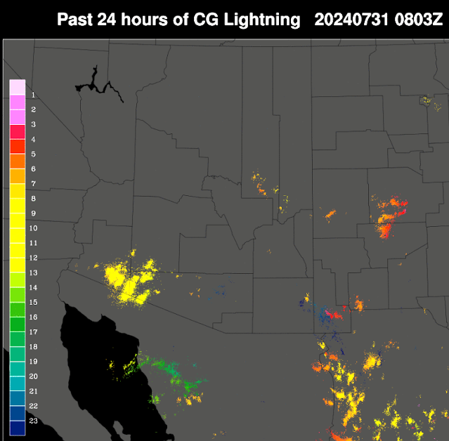
Plot of detected CG flashes for 24-hours ending at 0803 UTC last night (above from Atmo and Vaisala) shows almost no activity across all of Arizona, except for small cluster of storms north of GoC. Skies were clear and dry here at the house.


The 500 mb analysis this morning (above from SPC) shows a large, amorphous anticyclone centered around southern Arkansas. The morning sounding from TWC/TUS (below, also from SPC) is not very impressive, requiring deep heating to release its CAPE. Winds aloft are mostly southerly above 850 mb with some speeds up to around 25 kt.


While I don't find the sounding impressive, all the forecasts are indicating showers this evening. Plumes above for QPF at the airport from the 06 UTC runs average about a half an inch this evening. The 12 UTC WRF-HRRR (below) forecasts rainfall across all of the eastern half of Pima county by midnight tonight. The latest NWS forecast (bottom) indicates POPs of 40 to 50 percent at the airport this evening. Note also the advisory for blowing dust. Will be interesting to watch what actually happens.
Tuesday, July 30, 2024

Down Day

View of Catalinas at 7:45 am MST this morning shows somewhat dreary conditions overhead at that time.


Plot of detected CG flashes above shows none over eastern Pima County for 24-hours ending at 0703 UTC last night - note there could have been some rumbles around from in-cloud flashes.


Very limited and light precipitation at a few sites within the ALERT network for 24-hours ending at 7:30 am this morning (above and below). Amounts were generally less than about a quarter of an inch - nothing here. Most of main metro was suppressed.


At 500 mb (above from SPC) the amorphous anticyclone is off to the east. There does appear to be a weak, inverted trough nearby across the New Mexico boot heel stretching into northwest Sonora. The forecast from the 12 UTC WRF-RR run at Atmo (below) indicates almost no precipitation across all of Arizona through midnight tonight.


Forecast graphic (above) from the NWS at TUS - below shows the current forecast for the airport. Best chances for rainfall are indicated for Wednesday and Thursday nights.

Monday, July 29, 2024

Very Light Shower Here Yesterday


Sunrise, with some contrail, looking toward Redington Pass at 6:00 am MST this morning.


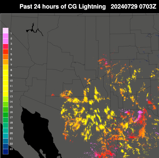
Plot of detected CG flashes (from Atmo and Vaisala) for 24-hours ending at 0703 UTC last night. There was considerable thunderstorm activity across eastern Pima County. Much rumbling thunder here after 4:00 pm or so.


However, there was only a very light evening shower that left only 0.02" in the gauge.  The airport had 0.04" and DM had 0.06", while Atmo remains out-of-service. ALERT network data (above and below - for 24-hours ending at 7:00 am this morning) show scattered sites with rain across entire network. There were a few sites with over half an inch, as well as two spots in the Catalinas with over an inch.


At 5oo mb (above) the anticyclone has shifted well eastward and is now centered over west Texas. The morning TWC/TUS sounding (below) continues to be onion-shaped, but with considerable PW and BL CAPE. Winds aloft continue light and mostly from the south below 200 mb.


The 12 UTC run of the WRF-RR forecasts almost no rain across all of Pima County through midnight tonight (above from Atmo). The current NWS morning forecast below for the airport is a bit more optimistic. Given all the activity yesterday, I'd vote for a mostly down day.

Sunday, July 28, 2024


View looking toward the Rincons at about 4:50 am MST this morning - note Jupiter in upper right.


Plot of detected CG flashes for 24-hours ending at 0903 UTC early this morning. - note that eastern Pima County was devoid of activity, except for one, isolated storm near the airport. There were only eight rain reports across the entire ALERT network through 8:30 am this morning (below). The heavy amount near the airport fell from the brief thunderstorm around 5:00 pm. Nothing here at the house yesterday.


The anticyclone at 500 mb this morning (above from SPC) is very elongated west-to-east and curves from southwestern Arizona to east Texas. The morning upper-air sounding (below - also from SPC) shows increased PW, considerable BL CAPE, and variable winds aloft with speeds up to around 20 kts. Appears that steering flow for any storms later today would be toward the north.


The 12 UTC WRF-HRRR (above - from Atmo) forecasts considerable rain across eastern Pima County through midnight tonight. Current NWS forecast for the airport is shown below.

Saturday, July 27, 2024

Midnight Showers

Sunrise looking toward Redington Pass at 5:45 am MST this morning.


Plot of detected CG flashes for 24-hours ending at 0733 UTC last night shows ongoing thunderstorm activity across southern parts of eastern Pima County.


The ALERT plots at 7:00 am this morning (above and below) show scattered sites with rainfall across northern portion of network, but all sites with rain in the southern part of the network. Heaviest amounts occurred to the south of the metro area. Here at the house we had only 0.03", while airport reported 0.34"; DM had a Trace and Atmo continues out-of-service.


Plumes for QPF at the airport (above - from the 06 UTC GEFS runs) above show best chances for rain occurring today and tomorrow. The operational GFS (blue) is a heavy-amount outlier. Current NWS forecast for the airport (below) keeps 40 to 50 POPs at airport today and tomorrow.

Friday, July 26, 2024

More Storms Plus Heavy Rains


First storm coming off the Catalinas at around 4:00 pm MST yesterday afternoon.


Plot of detected CG flashes (from Atmo and Vaisala) through 0703 UTC last night shows eastern Pima County totally covered.


Plots of observed rainfall across the ALERT network (for 24-hours ending at 6:00 am this morning) indicates that all sites had precipitation, with many reports over an inch and several over two inches. Here at the house we had 1.43", which is heaviest single event so far in 2024.


The reports from SPC for yesterday (above) show a number of severe wind events across south-central Arizona. I estimated gusts of 40 to 50 mph here; TUS reported thunder, gusts to 55 mph, and 1.83" of rain; DM had thunder, gusts to 32 mph, and 0.37" of rain; the rain gauge appears to be out-of-service again at Atmo, where winds gusted to 36 mph. Numerous sites around the area had temperature drops of almost 40 F around 6:00 pm.


The morning sounding from TWC/TUS (above) shows a deep onion shape, with quite a cool layer below 800 mb. Winds aloft are basically northerly, with strongest speeds up around 200 mb. The 500 mb anticyclone is centered over the northern GoC and is forecast to shift east-northeastward into New Mexico during the weekend.


The 12 UTC WRF-HRRR (above) forecasts just a bit of light precipitation through midnight in eastern Pima County. Given the widespread rainfall yesterday, and this morning's sounding, it should basically be a down day today. The current morning forecast from TUS NWS (below) seems a bit optimistic regarding rain POPs at the airport today and tonight. Time will tell.

Thursday, July 25, 2024

Heavy Storms Along Rillito


Early morning view of the Catalinas today. View at bottom is from yesterday afternoon after the storms here.


Plot of detected CG flashes through 0733 UTC last night (above from Atmo and Vaisala) indicates afternoon storm activity in north parts of eastern Pima County.


ALERT plot of rainfall reports through 7:00 am (above) and from MesoWest (below) show heavy amounts along foothills and the Rillito. Here at the house we had a heavy storm  around 4:00 pm with gusts around 40 to 50 mph (estimated). There was a report of gusts to 68 mph at 4:15 pm 7 miles north of the airport (which is near to our location).


The 500 mb analysis (above from SPC) shows a huge anticyclone centered over the Four Corners region. The morning sounding from TWC/TUS (below) continues moist, with a deep layer of several old BLs above the surface. There is considerable mid-level CAPE, and winds aloft are northerly to northeasterly at around 20 kts.


Forecast above (valid through midnight tonight) from the 12 UTC WRF-HRRR run at Atmo indicates rains across the metro area with some spots having heavy amounts. Current morning forecast from NWS TUS (below) continues to indicate high POPs for the airport through Saturday.