Saturday, August 31, 2024

End of August


View toward the eastern Catalinas at 6:00 am MST this morning.


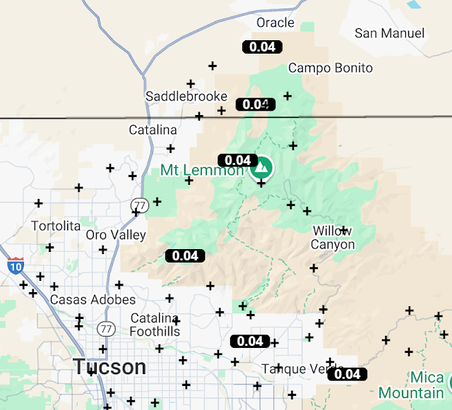
Plot of detected CG flashes (from Atmo and Vaisala, through 0733 UTC last night) indicates some scattered thunderstorm activity in eastern Pima County yesterday, mostly over and near the mountains. The ALERT observations below (through 7:00 am this morning) tell the same story. The airport and DM reported thunder but no rain. No rain here or at Atmo. There may have been thunder here, but I did not hear it.


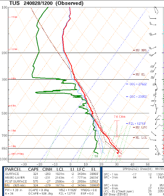
The 500 mb analysis (above, from SPC) this morning shows light winds across the Southwest, with the anticyclone center far to the north over Idaho. The morning sounding (below, also from SPC) has about an inch of PW and little to no CAPE. Winds are light and variable below 300 mb. I would not expect low elevation storms with this sounding, barring an increase in PW during the day (which is not forecast by models).


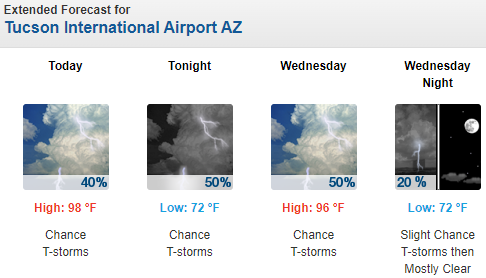
However, both the 12 UTC WRF-HRRR (above through midnight) and the NWS (current forecast below) disagree and forecast chances for storm at lower elevations and the airport. So, I will be interested to see what happens later today and this evening.

Thursday, August 29, 2024

More Sprinkles


Nice pre-sunrise color this morning looking toward Redington Pass at 5:50 am MST.


Yesterday was very suppressed over most of southern Arizona. Plot of detected CG flashes (above through 0813 UTC last night - from Atmo and Vaisala) shows no thunderstorm activity over eastern Pima County.


There were morning sprinkles and showers yesterday across the Catalinas and far southern parts of the ALERT network. There was a Trace here, as well as at DM and the airport.


At 500 the main anticyclone center has shifted to the Carolinas this morning and there appears to be a weak circulation over Nevada, as well as an inverted trough over western Arizona and southern California (above analysis from SPC). Wind speeds remain quite light at 500 mb. The morning sounding is relatively dry and quite stable (below, also from SPC).


Plumes for QPF at the airport from the 06 UTC GEFS (above) indicate a quiet ending of the month for August. The 12 UTC WRF-HRRR forecast through midnight (from Atmo - below) indicates little rainfall over much of Arizona, including Pima, Santa Cruz, and Cochise Counties.

Wednesday, August 28, 2024

Light Sprinkles


Some color on the Catalinas at 6:00 am this morning.


There were a couple of small clusters of CG flashes in eastern Pima County near the mountains yesterday afternoon - plot of CG flashes through 0803 UTC last night shown above (from Atmo and Vaisala). May have been thunder here, but I didn't hear it.


Limited reports of light rainfall amounts across the Alert network through 7:30 am this morning (above and below). There was a very light sprinkle and Trace here late yesterday afternoon.


The morning 500 mb analysis (above from SPC) shows the anticyclone has weakened significantly and moved over the southeastern US. Pattern is very chaotic over the Southwest with slight height gradients and light/variable winds.

Morning sounding from TWC/TUS has appeared (below, also from SPC), so the office must have received a helium shipment. Sounding shows moisture and some CAPE above 700 mb. There are southwest winds of 20 to 30 kts above 500 mb, but light and variable winds below. The current morning forecast from the Forecast office for the airport is shown at bottom.


Tuesday, August 27, 2024

More of the Same


Bit of color over the eastern Catalinas at about 6:00 am MST this morning.

Plot of detected CG flashes through 6:00 am (below - from Atmo and Vaisala) shows only a few flashes in all of eastern Pima County yesterday afternoon. Heard rumbles of thunder here from strikes in the foothills to north - but not even a sprinkle of rain fell.


Only six sites in the ALERT network observed rainfall through 6 am (above). Amounts were light, with heaviest being only 0.12" near Mt. Lemmon.


At 500 mb (above from SPC) The large anticyclone center is now over southern Illinois, with perhap a second, weak center over lower Colorado River. There is a closed, upper-tropospheric low over south Texas (not an easterly wave as per recent NWS forecast discussions). Winds at 500 are very weak over the entire southwest US. 

The 06 UTC run of the WRF-GFS at Atmo (below) indicates some scattered, light showers in eastern Pima County by midnight tonight.


Morning graphic (above from NWS) with current forecast below - NWS forecasts considerable more storm activity than does the WRF.

Monday, August 26, 2024

Another Mostly Down Day


Evening storm over Redington Pass at 6:45 pm MST yesterday.


Plot of detected CG flashes through 0733 UTC last night (from Atmo and Vaisala) shows some storm activity that occurred mostly over the mountains of eastern Pima County.  There were only seven sites across the ALERT network that reported 0.04" or more rainfall through 7:00 am this morning. Three were around Redington Pass and four were across the southern portion of the network, Heaviest amount was 0.16" at Florida Canyon in the northern Santa Ritas. Another quiet day here at the house.


At 500 mb this morning (above from SPC) the anticyclone is centered over northern Missouri, while Arizona is under the influence of the western trough. Certainly not a very monsoon-looking pattern with only a week left in August.


The 12 UTC run of the WRF-HRRR at Atmo (above) forecasts almost no rainfall over most of Arizona through midnight tonight, with a focus on Santa Cruz County. A five day outlook for southeastern Arizona from the NWS Forecast Office is below - the tables are not very readable unless you visit their webpage.

Sunday, August 25, 2024

Another Quiet Day Yesterday


View of the Catalinas at 7:00 am MST this morning with a band of middle cloud overhead.


Plot of CG flashes (above from Atmo and Vaisala) for 24-hours ending at 7:00 am shows little storm activity in eastern Pima County yesterday afternoon.  The ALERT observations through 7:00 am (below) show only four sites with reported rain amounts. Nothing here at the house.


The morning 500 mb analysis (above, from SPC) shows that the trough over the West has moved well inland, nudging the anticyclone center over northern Missouri.


The 12 UTC run of the WRF-HRRR at Atmo (above) shows some rain through midnight, mainly southeast of the metro area. Current forecast from the NWS for today and tomorrow is shown below. Note that none of the forecasts yesterday (see previous post) verified well.

Saturday, August 24, 2024

Light Showers Yesterday

Buildups over the Catalinas at 5:50 am MST this morning.


Plot of detected CG flashes (above, from Atmo and Vaisala for 24-hours ending at 0803 UTC last night) indicates widespread thunderstorm activity over eastern Pima County yesterday afternoon.

The ALERT network observations (below for 24-hours ending at 7:00 am this morning) show essentially 100 percent coverage across the main metro area. However, amounts were generally light, with only five sites reporting half an inch or more. Here at the house we had 0.15" during a thunderstorm around 5:00 to 5:30 pm; the airport reported  thunder with gusts to 49 mph and 0.10"; DM had 0.13"; and Atmo came in with 0.11".


Data continue missing for Tucson, but 500 mb analysis (above from SPC) indicates winds across Arizona from the southwest at 30 to 40+ kts. The anticyclone center has shifted to the Kansa/Oklahoma border.


The 12 UTC run of the WRF-HRRR at Atmo forecasts rainfall through midnight mostly near and west of the airport. The morning forecast from the NWS (below) continues to forecast POPs of 20 to 30 percent.

Friday, August 23, 2024

Sprinkles Yesterday


Colorful skies looking toward Redington Pass at 5:50 am MST this morning.


Plot of detected CG flashes (above, from Atmo and Vaisala) for 24-hours ending at 0803 UTC last night shows a typical metro donut hole.


Rainfall across the Alert network yesterday (above and below) was widely scattered, with heaviest amounts in the southern part of the network and little in the main metro area. We had thunder and a Trace here, as did the airport and DM, while Atmo reported no rain.


The TWC/TUS upper-air data remain missing, and there is still no info from the NWS Forecast Office regarding this situation. The morning 500 mb analysis (above from SPC) indicates southwesterly winds of 30 to 35 kts over Arizona. The 12 UTC WRF-HRRR forecast through midnight (below, from Atmo) indicates storms today only near and over the mountains.


Morning graphic for today (above) and the current forecast for the airport (below) from the NWS. The POPs through the weekend are basically climatological values for this time of year, so nothing really to focus on.