View of Catalinas above at 7:33 am MST this morning. Bottom shows storm and rain over part of metro area yesterday afternoon at 4:20 pm. Plot of detected CGs (below - from Atmo and Vaisala). Storms are ongoing northeast of Phoenix.
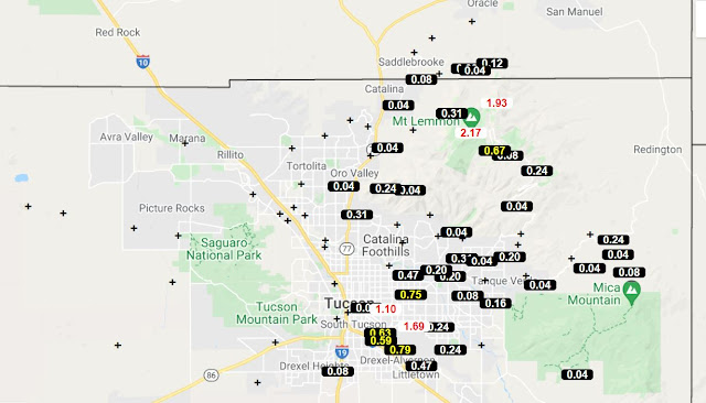
ALERT rainfall for 24 hours ending at 8:30 am this morning - rain over much of eastern half of network. Nothing here at the house.
The morning 500 mb analysis (above from SPC) shows a weak short wave across southern California down into northern portion of GoC. This feature will move across Arizona and should enhance thunderstorm activity this afternoon.
The morning sounding from TUS/TWC (skewT plot below) shows a Fall-like wind profile with southwesterly winds through the troposphere. Moisture and CAPE remain very high. However the T/Td profile appears suspect from about 750 mb up to near 500 mb. This layer shows absolute instability. I suspect the sensor got wet.
Once the trough moves by, we should be under the influence of drier air and fair skies, extending perhaps through the weekend. Will be nice change.
Finally, Tropical Storm Grace (above) is forecast to strengthen and move across Yucatan (current track forecast below) and then dissipate over the mountains of central Mexico. Will wait to see whether her remains end up moving into the southern end of the GoC.


No comments:
Post a Comment