Friday, July 31, 2020
End Of July
Morning view from campus at 6:30 am MST this morning. Down at bottom is view of a wildfire burning near Mt. Wilson Observatory, in California, yesterday afternoon.
Extremely suppressed yesterday wrt thunderstorms. Plot above shows detected CG flashes for 24-hours ending at 1:00 am this morning (from Atmo and Vaisala). What can I say?
I have been noticing, for a number of weeks, that the operational GFS forecasts are wet outliers, in comparison to the GEFS forecast members. Don't know why this strange behavior is happening. Regardless, the GEFS forecasts indicate a very dry start to August.
From the NWS webpage, plot above shows rainfall since June 15th for a number of stations in southeast Arizona. Here at house we had much more rainfall in July than did the airport, thanks to the heavy storms on the 23rd in this part of town. July ended up with 1.97" here, which is about at the median for my 22 years of observations.
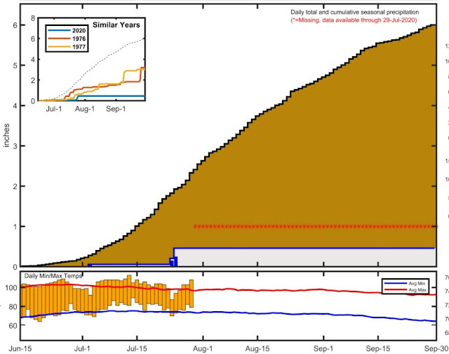
Mike Crimmins' running plot for the summer so far at airport is shown below. Links to Mike's plots for a large number of sites are available at:
https://cals.arizona.edu/climate/misc/monsoon/monsoon_summaries.html
Subscribe to:
Post Comments (Atom)


No comments:
Post a Comment