More middle clouds overhead today.
Visible satellite image at a bit after 7:00 am MST this morning (above) shows widespread debris cloudiness over eastern Arizona. Hurricane Hanna is nearing landfall around Corpus Christi this morning. Remains to be seen whether residual showers and cloudiness from the storm will reach this far northwest.
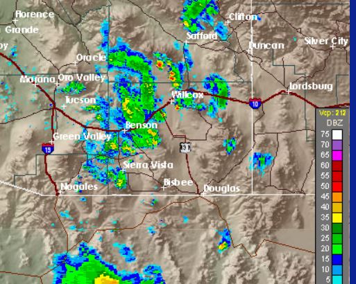
Yesterday had very limited thunderstorm activity, as is typical after a widespread rain day. Not sure why NWS hung on to POPs greater than 50% through most of day. Above shows radar echoes at 7:00 pm and below is detected CGs (from Atmo and Vaisala) for 24-hours ending at 8:00 am this morning.
Metro area ALERT reports for 24-hours ending at 8:00 am this morning is second below - few amounts and they are very light, except for one site in the Catalinas
An aside - using the old meteorological definition of the start of monsoon (i.e. three consecutive days of average dewpoint 54 F or greater at airport) is preferable (to me), rather than just saying there is a "Monsoon Season" period beginning June 15th, as per current NWS practice. Plot of average daily dewpoint (below) at TUS indicates, by old definition, monsoon began here on July 22nd - about two weeks later than usual.


No comments:
Post a Comment