Large Cb to the distant east-northeast last evening as the sun set.
Was a suppressed day locally yesterday, with some thunderstorm activity to east and south in Cochise and Santa Cruz Counties. Composite radar chart above is from 5:00 pm MST yesterday, and plot of detected CG flashes (below - from Atmo and Vaisala) is for 24-hours ending at 1:00 am this early morning.
Visible satellite image above is from about 7:30 am this morning. Hurricane Hanna has dissipated, but left heavy cloud cover across central Mexico. Also a bit of debris cloudiness drifting across Cochise County.
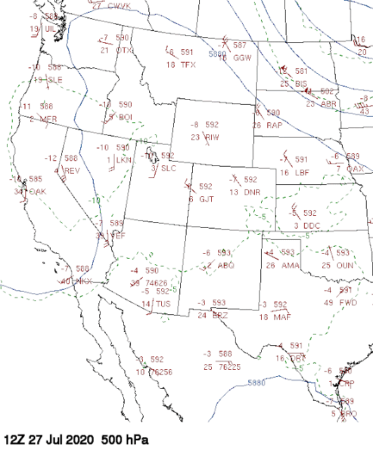
The 500 mb analysis this morning (below from University of Wyoming weather page) shows a large but weak trough along West Coast and a very large, and also weak, anticyclone covering the rest of the West. The high's main circulation center is between Amarillo and Midland, Texas. The observed 500 mb temperatures are very warm over southern Arizona and northern Mexico, i.e., -3 to -5 C which is a distinct negative for storms over lower elevations.
The morning sounding at TWC is also a very mixed bag: winds are very light below 300 mb; residual BL is shallow with drying 850 to 700 mb; however, PW is high, at just over an inch and a half. There are no clear steering level winds that would move storms far from higher elevations.
The 12 UTC WRF-NAM forecast below is for rain amounts through midnight tonight. Amounts are very light and also suggest a Tucson donut hole.
Between now and Wednesday morning, the main anticyclone center shifts westward, ending up to our west and northwest for much of coming week - not a good pattern for precipitation chances here. So, today may be last shot for July rain. Here at house, I'd be amazed if we get rain in the gauge, since the storm would have to develop nearly overhead, or build southwestward off the Catalinas.


No comments:
Post a Comment