Monday, July 29, 2019
Increased Activity Today
Phone shot by Katie of sunset colors behind the Santa Ritas last Friday evening.
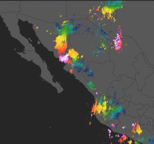
There was only a bit of thunderstorm activity in far southeast Arizona yesterday afternoon, and storms pretty much were stuck on the mountains. The plot of CG flashes for 12-hours ending at 7:30 am MST (above, from Atmo and Vaisala) shows that active flashes are still being detected with an MCS over northwestern Mexico. The IR image below from 6:30 am shows the MCS, as well as TSs Erick and Flossie far to south. These storms are expected to become hurricanes by the NHC as they move a bit north of west away North America.
The 500 mb analysis this morning (above from SPC) indicates the anticyclone - centered somewhere over northwestern New Mexico - dominates much of the West, There is perhaps a weak, inverted trough over northern Sonora. Morning sounding plot below for TWC (also from SPC) shows PW up to about an inch and a half with some CAPE. However, wind field remains very weak and disorganized.
The 06 UTC WRF-GFS forecast from Atmo (above valid at 6:00 pm this afternoon) shows some CAPE and easterly steering winds that are weak. Thus, storms may have trouble moving away from mountains again today.
The forecast of radar echoes (below, from same model run) is valid at 9:00 pm this evening with widespread thunderstorm activity over southeastern Arizona. So, perhaps some chances for additional rainfall before July comes to an end - only 1 inch of rain so far for entire month here at house.
Subscribe to:
Post Comments (Atom)


No comments:
Post a Comment