Heavy clouds over the Catalinas at 6:20 am MST this morning, with rain on foothills and mountains. Down at bottom is a view yesterday just before noon - the heavy rain-shaft at left-center is right over our house.
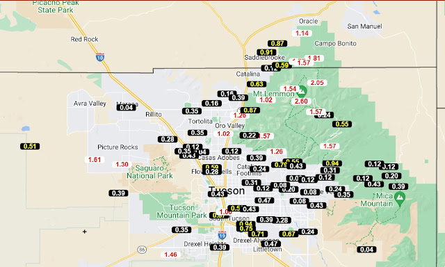
ALERT network data show widespread rains for 24-hours ending at 7:00 am this morning. Only one site did not have 0.04" or more during the period. Many places had rain both yesterday and again after midnight. Here at the house we had 0.24" yesterday and another 0.21" after midnight last night. Across the network there were about 40 sites with more than half an inch, and 20 sites had more than an inch. All-in-all it was quite a significant event. Atmo reported 0.23" and the airport measured 0.26", but DM had a direct hit by a heavy cell and got 0.89".
Interestingly, the plot of detected CG flashes (from Atmo and Vaisala) for 24-hours ending at 0630 UTC (second below) shows a donut hole over much of the metro area - so limited thunderstorms but plenty of rain.
Forecast below is from the 12 UTC WRF-RR and is for rainfall through midnight tonight. However, the model forecasted rain ends by noon. Given the heavy cloud cover, I will be surprised if there is enough heating to generate a new round of storms today.


No comments:
Post a Comment